Miguel Ángel Puig-Samper
During his trip to New Spain in 1803, Alexander von Humboldt visited large tracts of New Spanish territory, which includes modern Mexico and part of the United States. This trip provided the data for his geographical Atlas of the region, as well as information about the ancient Mexican cultures that he would later include in the general Atlas and in other major works, such as Vues des Cordillères. Likewise, Humboldt’s Political Essay on the Kingdom of New Spain displayed a comprehensive physical, natural, economic, and social description of Mexico in the colonial period, which will also be analysed. With these works, Humboldt presented a new geographical and cultural image of New Spain to the European audiences. In addition to this, his work made important contributions to cartographic knowledge.
Alexander von Humboldt en su viaje a Nueva España en 1803 tuvo la oportunidad de viajar por gran parte del territorio novohispano, que incluye Mexico y parte de del actual territorio de Estados Unidos. Este viaje le permitió preparar un Atlas geográfico de la región, además de obtener información sobre las antiguas culturas mexicanas que luego plasmará en el Atlas general del viaje y en algunas de sus principales obras como Vues des Cordillères. Asimismo, Humboldt hizo una excelente descripción física, natural, económica y social de México en la época colonial en su Ensayo político sobre el Reino de la Nueva España que también será analizado. Con estas obras Humboldt logró ofrecer una nueva imagen del territorio novohispano y sus riquezas al mundo europeo, así como un conocimiento cartográfico de gran importancia.
Alexander von Humboldt, lors de son voyage en Nouvelle-Espagne en 1803, a eu l’occasion de parcourir une grande partie du territoire de la Nouvelle-Espagne, qui comprend le Mexique et une partie du territoire actuel des États-Unis. Ce voyage lui a permis de préparer un Atlas géographique de la région, ainsi que d’obtenir des informations sur les anciennes cultures mexicaines qu’il inclura plus tard dans l’Atlas général du voyage et dans certaines de ses œuvres principales comme Vues des Cordillères. Humboldt a également donné une excellente description physique, naturelle, économique et sociale du Mexique à l’époque coloniale dans son Essai Politique sur le Royaume de la Nouvelle Espagne, qui sera également analysé. Avec ces travaux, Humboldt a réussi à offrir au monde européen une nouvelle image du Nouveau territoire espagnol et de ses richesses, de même qu’une connaissance cartographique de grande importance.
Alexander von Humboldt’s trip to New Spain was a wonderful experience that was to leave a deep impression on him, to the point that he even toyed with the idea of moving to Mexico City permanently, as he was overwhelmed by its beauty, its highly developed institutions, including scientific ones, and its economic potential.
While he prepared for his departure in Madrid, in the first semester of 1799, he was already dreaming about his American trip and his visit to Mexico. In a recently found letter, his friend the Prince of Parma, son-in-law of King Charles IV, asked the future viceroy of New Spain, Miguel de Azanza, to protect Humboldt and provide him with whatever he needed for his research:
Aranjuez 4 May 1799
My dear friend: Mr Alexandro Humboldt, Prussian, who will hand you this letter from me, is highly learned in Chemistry, Natural History and Mineralogy. I have known his writings for a few years, and this year I had the pleasure to meet him in person. Now he passes to America, with H. M.’s license, and, as he knows that you are my friend, he asked me to write this letter, which I did with pleasure, and hope that you will oblige me by lending him whatever help your duties allow for his trip, research, etc.
It is always a pleasure to write to you, as it allows me to express again my esteem, recognition, and affection.
Most dear Azanza
Your dearest friend
Luis P. de Parma1
A few years later, on 28 March 1803, Alexander von Humboldt wrote to the new viceroy of New Spain, José de Iturrigaray, to announce his recent arrival to the port of Acapulco and to inform him of his intention to travel to Mexico City. Humboldt made his services available to the viceroy, whom he knew to be a keen sponsor of science and the benefactor of other scholars interested in Mexico’s natural phenomena, such as Fausto de Elhuyar, Andrés Manuel del Río, Martín de Sessé, and Vicente Cervantes.2 In mid-April, Humboldt received Iturrigaray’s answer, in which the viceroy offered him his full support, including even the possibility of taking a trip together. In the report that Humboldt wrote in Philadelphia, before returning to Europe, Humboldt mentions that he had arrived at New Spain in the company of Aimé Bonpland and Carlos Montúfar:3
Mr. Humboldt had originally the intention to remain only a few months in Mexico, and to hasten his return to Europe; his voyage had already been too much protracted, his instruments, particularly the chronometers, began to be out of order, and every effort that he made to have new ones sent to him proved of no avail; add to this consideration, that the progress of science is so rapid in Europe, that, in a journey that lasts four or five years, great risk is run of contemplating the different phenomena under aspects, which are no longer interesting at the moment of publishing the result of your labours. Mr. Humboldt hoped to be in France in August or September, 1803, but the attractions of a country, so beautiful and so varied, as is that of the kingdom of New Spain, the great hospitality of its inhabitants, and the fear of the yellow fever, so fatal, from June to November, for those who come from the mountainous parts of the country, led him to stay a year in this kingdom.
According to Ramón Serrera, Viceroy Iturrigaray played a central role in Alexander von Humboldt’s work in New Spain,4 welcoming him, giving him access to local archives, and putting him in contact with the main scholars in Mexico.5 When Viceroy Iturrigaray’s performance in office was audited (juicio de residencia), he was charged with allowing the presence of foreigners in New Spain, and Humboldt’s name was explicitly mentioned in the accusation. Iturrigaray died in Madrid in 1815, but this did not mean the end of the juicio de residencia, in which the viceroy’s solicitor argued that Baron von Humboldt was merely a writer and a visitor who did not actually settle in Mexico, and that he had been warmly welcomed by first-rate citizens because of his extraordinary qualities. In addition, it was argued, he always travelled with the right permits, and was from another kingdom. On 17 February 1819, the Council of the Indies ruled posthumously against Iturrigaray on several counts, but cleared him of most of them, including the one to do with Humboldt.
The summary of Humboldt’s trips through New Spain can also be found in the Philadelphia report:
Our travellers ascended from Acapulco to Tasco, celebrated for its mines, as interesting as they are ancient. They rise, by small degrees, from the ardent valley of Mescala and Papagayo, where the thermometer of Reaumur stands, in the shade, constantly from 28 to 31 (95 to 101 Fah.), in a region 6 or 7000 toises above the level of the sea, where you find the oaks, the pines, and the fougere (fern) as large as trees, and where the European grains are cultivated. They passed by Tasco, by Cuerna Vacca (sic), to the capital of Mexico. This city, of 150,000 inhabitans, is placed upon the ancient site of Texochtitlan (sic), between the lakes of Tezcuco (sic) and Xochimilco, lakes which have lessened somewhat since the Spaniards have opened the canal of Hacheutoca (sic), in sight of two snow-topped mountains, of which one, Hopocatepec (sic), is even now an active volcano, surrounded by a great number of walks, shaded with trees, and by Indian villages.
This capital of Mexico, situated 1160 toises above the sea, in a mild and temperate climate, may doubtless be compared to some of the finest towns in Europe. Great scientific establishments, such the Academy of Painting, Sculpture, and Engraving, the College of Mines, (owing to the liberality of the Company of Miners of Mexico), and the Botanic Garden, are institutions which do honour to the government which has created them.
After remaining some months in the valley of Mexico, and after fixing the longitude of the capital, which had been laid down with an error of nearly two degrees, our travellers visited the mines of Moran and Real del Monte, and the Cerro of Oyamel, where the ancient Mexicans had the manufactory of knives made of the obsidian stone. They soon after passed by Queretaro and Salamanca to Guanaxoato (sic), a town of fifty thousand inhabitans, and celebrated for its mines, more rich than those of Potosi have ever been. The mine of the count of Valenciana, which is 1840 French feet perpendicular depth, is the deepest and richest mine of the universe. This mine alone gives to its proprietor nearly six hundred thousand dollars annual and constant profit.
From Guanaxoato (sic) they returned by the valley of St. Jago (sic) to Valladolid, in the ancient kingdom of Michuacan (sic), one of the most fertile and charming provinces of the kingdom. They descended from Pascuaro (sic) towards the coast of the Pacific Ocean to the plains of Serullo (sic), where, in 1759, in one night, a volcano arose from the level, surrounded by two thousand small mouths, from whence smoke still continues to issue. They arrived almost to the bottom of the crater of the great volcano of Serullo (sic), of which they analized the air, and found it strongly impregnated with carbonic acid. They returned to Mexico by the valley of Teluca, and visited the volcano, to the highest point of which they ascended, 14,400 French feet above the level of the sea.
In the months of January and February, 1804, they pursued their researches on the eastern descent of the Cordilleras, they measured the mountains Merados, de la Puebla, Popocatyce (sic), Izazihuatli (sic), the great peak of Orizaba, and the Cofre de Perote; upon the top of this last Mr. Humboldt observed the meridian height of the sun. In fine, after some residence at Xalappa (sic), they embarked at Vera Cruz (sic), for the Havannah. They resumed the collections they had left there in 1801, and by the way of Philadelphia, embarked for France, in July, 1804, after six years of absence and labours.6
Although Alexander von Humboldt’s cartography of New Spain, as well as his many drawings, are spread over several works, I think that his most important cartographic contribution is the Atlas Géographique et Physique du Royaume de la Nouvelle Espagne (Paris, 1808 and 1811).7 The true value of this work, however, can only be understood in conjunction with the geographical introduction of his Ensayo político sobre el Reino de Nueva España, in which the plates published in the Atlas are explained.
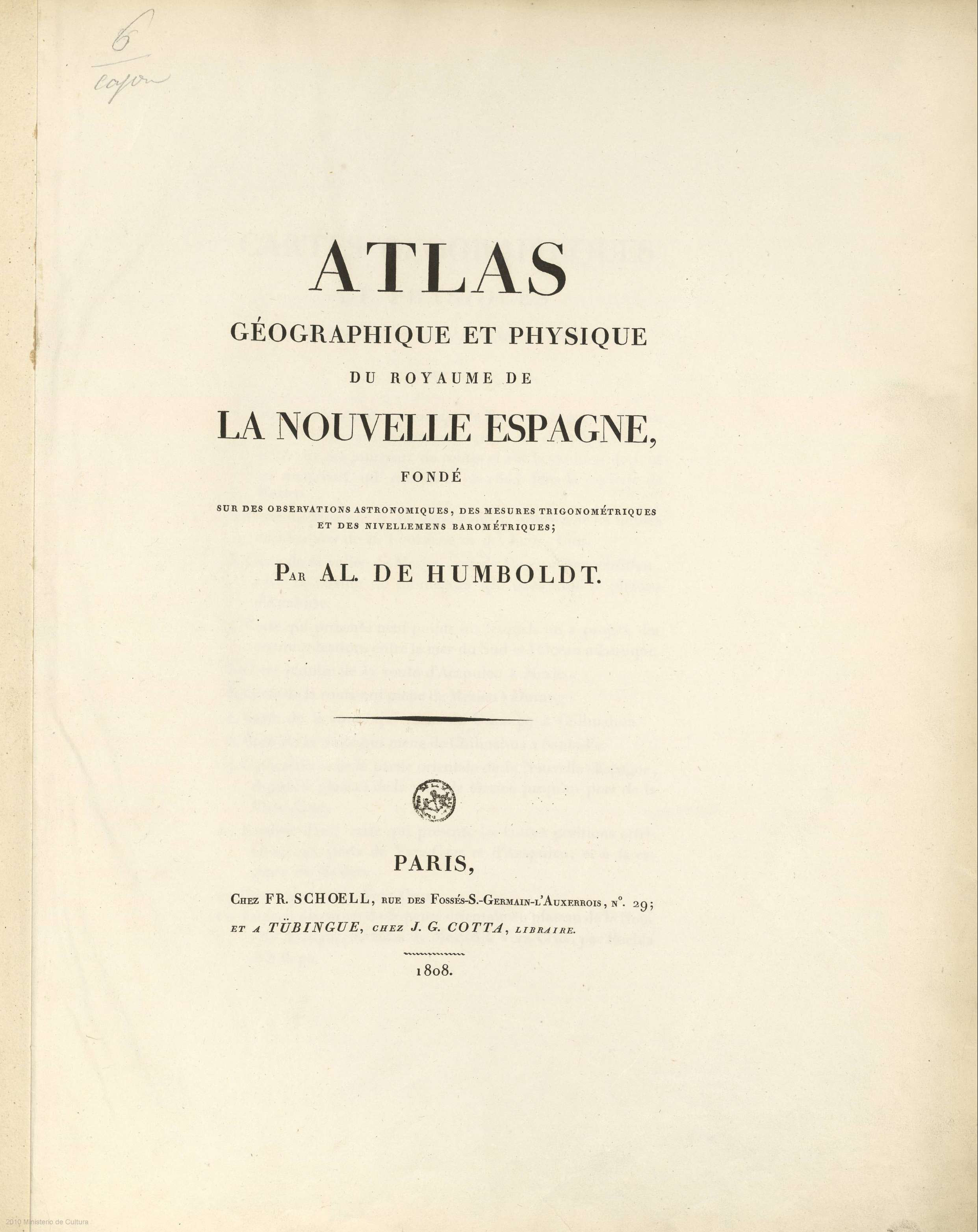
Fig. 1: Cover of Atlas Géographique et Physique du Royaume de la Nouvelle Espagne, Alexander von Humboldt. Biblioteca virtual del Ministerio de Defensa. Spain.
In the opening paragraphs of this introduction, Humboldt explains that his cartographic efforts had focused on geographical maps, and on representing the unevenness of Mexican territory through vertical projections, something he also did in the Iberian Peninsula (these sections were published in the journal Hertha in 1827). There is little doubt that his training as geographer and naturalist had brought him closer to classic maps, but his time at the Freiberg mining school also taught him the value of topographic sections and pasigraphic representation, as noted in the appendix of Andrés Manuel del Río’s geological work, written for the students of the mining school in Mexico City. Humboldt also wanted to make clear that his Atlas was to a large extent based on his own astronomic and geodesic observations, although he also admitted using plans and manuscripts held in archives and convents in New Spain.
Humboldt trusted that his astronomical works, carried out with Jabbo Oltmanns, in combination with his Mexican statistics – the famous Tablas geográficas handed to Viceroy Iturragaray –, and the historical account of his trip to the tropics, sufficed to prove that his trip had been guided by his love for truth and wish for accuracy. The preamble ends with a humble praise of nature’s beauty:
“May my feeble labours contribute something to dispel the darkness which for so many ages has covered the geography of one of the finest regions of the earth”.8
The Atlas included twenty copper-etched plates: maps, topographic sections, itineraries, and views. As indicated by the subtitle, the Atlas, which illustrates Ensayo político sobre el reino de la Nueva España, is based on astronomical observations, trigonometric measurements, and barometric levels. It contains the general map of the kingdom of New Spain, two smaller maps – also included, folded, in some editions of the Ensayo politico – the map of Mexico and its northern and eastern neighbours and the map of the valley of Mexico and the surrounding mountains; other partial maps; views; and topographic sections. As noted by Carmen Manso,9 one of these sections, the Tableau physique de la pente Orientale du Plateau de la Nouvelle Espagne, corresponds to a manuscript map entitled Representación geognóstica del declive oriental del Reyno de Nueva España, held by the Real Academia de la Historia. Manso argues that one of Humboldt’s foremost contributions to the knowledge of New Spain was the Atlas’s general map. When he returned to Europe, Humboldt brought with him the original diaries, field sketches, maps, and sections, as well as botanical and geological samples collected during his expedition, in preparation for the publication of his American trip. We also know that much of the cartographic material was perfected in Paris with the aid of professional draughtsmen and engravers before the publication of the Atlas géographique et physique du royaume de la Nouvelle-Espagne (Paris, 1811).
For this and other maps of New Spain, he had the assistance of Fausto de Elhuyar and a number of students in Mexico’s mining school: Mariano Jiménez; Casimiro Chowel; Ramón Fabié; Isidro Vicente Valencia; Rafael Dávalos; Juan José de Oteiza; J. J. Martínez de Lejarza; Juan José Rodríguez; Manuel Antonio Castro; Manuel Cotero; Manuel Ruiz de Tejeda; and Juan Arezorena.
The Carte Géneral du Royaume de la Nouvelle Espagne is the first of the Atlas’s twenty plates. Some of the copies feature the date 1809. The Carte géographique general du Royaume de la Nouvelle Espagne was drafted in the Real Seminario de Minería in late 1803, shortly before Humboldt’s departure from Mexico. As pointed out by Carmen Manso, the map was later improved before it was etched in copper. The title cartouche, on the top right, is simple, with undulating lines that spring from the letter shafts and weave around one another to elegantly frame the text. This text says that the map was ‘perfected by myself, M. M. Friesen, Oltmanns and Thuilier’. The engraving was undertaken by Barriere, and the lettering, of outstanding quality, by L. Aubert Sr. The toponyms are written in Spanish, like the manuscript letter, but some explicative texts were translated into French. In any case, a number of additions and corrections were introduced to the original manuscript version between 1803 and 1808.
The merits of the Carte Géneral du Royaume de la Nouvelle Espagne were universally praised throughout the first half of the 19th century, and the map was the key reference for later maps of Mexican territory. First, Humboldt prepared what he called the Mapa reducido del reino de Nueva España, which in the publication of the Atlas is found, taking two pages, as Carte Géneral du Royaume de la Nouvelle Espagne, carried out by Humboldt between 1803 and 1804 and modified in 1809 with the aid of Friesen, Oltmans and Thuilier. This map was begun at the Real Seminario de Minería with the help of its director, Fausto de Elhuyar, who gave Humboldt information about the position of the mines of New Spain and about the 37 districts known as Diputaciones de Minas; this information was of great economic and technical relevance.
Although Alexander von Humboldt complained more than once about not finding the documents compiled by Viceroy Revillagigedo, we know that, thanks to the passport granted by the Spanish Crown, he had, in fact, the opportunity to consult many of them, as well as other materials collected by previous viceroys (Miguel José Azanza and Félix Berenguer). He actually writes that, because he found so much material when his astronomical observations were already under way, he decided to change his cartographic targets. Mexican geography was poorly known, and it seems difficult to accept that in the few months he was planning to stay (eventually he was there for a year) he could realistically aspire to produce a perfect map of New Spain. In any case, Humboldt thought that his work – a mixture of astronomical and geodesic observations, compared with existing maps – would improve on anything that had been published before. He thought that, if the scarcity of reliable observations were enough reason to give up the idea of the map, the same reasoning could be applied to Spain, Poland, and even his beloved Germany, where fifteen years earlier there were barely twenty points in the central regions of the country whose longitude was known with some degree of certainty.
Writing about the obstacles in place to elaborate a general map of New Spain, Humboldt mentioned the unreliability of measurements taken north of the 24th parallel, in the so-called inner provinces, where he had to rely on existing travel accounts. Referring to the desert, for instance, Humboldt simply wrote that it began north of the city of Durango. In contrast, for the regions between Acapulco and Veracruz, which he visited personally, and which were among the most densely inhabited, he was able to draw on a large number of points whose astronomical position were known.

Fig. 2: Alexander von Humboldt. General Map of the Kingdom of New Spain. Biblioteca virtual del Ministerio de Defensa. Spain.
In order to gain a better understanding of the territory of New Spain, Humboldt suggested a three-way exploratory trip in northern New Spain, armed with a sextant or a circular sextant, a chronometer, an achromatic telescope, and a portable barometer, with which to measure the height of mountains. The routes suggested were: one, from Guanajuato to Santa Fe or the town of Taos, in New Mexico; two (the most important of the three), from the mouth of the Norte River to the Sea of Cortés; and three, from Mazatlán, in Sinaloa, to Altamira, in the left margin of the Panuco River. In Humboldt’s opinion, these three low-cost trips could change the face of New Spain’s geography forever.
The position of Acapulco, Veracruz and Mexico had already been verified by Dionisio Alcalá-Galiano, José Espinosa, Ciriaco Ceballos, Antonio León y Gama, José Joaquín Ferrer, and Humboldt himself. Spanish navy officers deployed in the port of San Blas could easily establish the position of the Bolaños mines and the city of Guadalajara, and Ceballos and Herrera were going to determine the position of the mouth of the Huasacualco River, southwest of Veracruz, and could do so also with the port of Tehuantepec and the Barra de San Francisco, in the mouth of the Chimalpa River. Humboldt argued that this plan was easy to execute and not too costly, as he trusted the abilities of Spanish naval officers, as he illustrated by mentioning Cosme de Churruca and Joaquín Francisco Fidalgo’s cartographic work in the coast of South America.
Humboldt acknowledged that measurements taken in the interior of the country could not be as precise as those taken on the coastline but recommended using the method that he had deployed to establish the difference in longitude between Mexico City and Veracruz; for this he used geometrical measurements, taken from the ancient pyramid of Cholula, the peak of Orizaba, and the Popocatepetl volcano, and trigonometric calculations.
The baron also proposed the use of a curious technique developed by Cassini de Thury and Lacaille. The technique was based on observations points situated on isolated summits in the middle of the plateau, such as the Iztaccihuatl and Cofre de Perote, from which to measure distances to gunpowder explosions and, using the right equipment, establish the ‘exact geographical time’. The method could also be deployed by Spanish navy officers and members of the Escuela de Minería de Mexico, who possessed both the right skills and a deep understanding of the geography of New Spain.
Another interesting topic in the analytical section of Alexander von Humboldt’s Atlas is what he regarded as the secrecy of Spanish scientific practice. According to him, the time when governments sought to keep the territorial wealth of the Indies secret for security reasons was long gone. Now, the Spanish king instructed his Depósito Hidrográfico to publish charts and maps in all detail and was no longer concerned with keeping the scientific and technical achievements of his monarchy concealed. It has been argued that Humboldt took advantage of, and even appropriated, the work of Spanish and Creole scientists without acknowledging their contribution. The Atlas’s introduction firmly undermines this idea; as we shall see momentarily, Humboldt cited all previous works and the cartographic material he consulted for his maps of New Spain.
First, Humboldt claims to have used Mercator’s projection, the advantage of which was to directly represent the real distance between two points, as well as being the favourite of sailors. The scale of the map was 32 millimetres per degree at the equator, and the increasing latitude scale was based on José de Mendoza y Ríos’s calculations for the spheroid, published by Connoissance de temps in 1793. Similarly, he argued that, for the map of Mexico to be as conveniently represented as possible, he had kept it within 15° to 41° N, and 96° to 117° W, even if this left out the intendencia of Mérida and the peninsula of Yucatán, which were also part of New Spain. The map also left out the Spanish settlements in the northeast coast, as this would have meant the addition of eight more degrees of longitude to the W. The northernmost location in the map was the presidio of San Francisco, which according to Vancouver was situated in 37° 48ʹ 30ʺ N-124° 27ʹ 45ʺ W.
In order to address the exclusion of these regions from the previous map, Humboldt drafted a much smaller map that included all the territories of the viceroyalty of New Spain, which reached as far as the Antilles and the modern United States. This map, which featured in the Atlas as Carte du Mexique et des Pays Limitrophes situés au Nord et à L’Est, was drawn, based on Humboldt’s Carta general de Nueva España and other materials, by J. B. Poirson in 1811.
For his maps, Humboldt used the Paris meridian as reference, although he claimed that he would have liked to use the universal meridian proposed by Laplace. Humboldt criticised some countries for using several meridians simultaneously, for instance Spain (Cádiz; Cartagena; Isla de León; Colegio de Nobles de Madrid; Punta Galera, in the island of Trinidad; Tenerife; and El Hierro), which was a source of endless confusion. For the denomination of the seas that surrounded Mexico, Humboldt followed Fleurieu’s Observations sur la division hydrographique du globe, although he added Spanish names for ease of reference.
Before describing his cartographic sources, Humboldt provided some details about the methods used to draw his Mexican maps:
I have followed, in the denomination of the seas which wash the coasts of Mexico, the ideas proposed by M. Fleurieu in his observations on the hydrographical division of the globe; a work in which the most enlarged views are united to a profound historical erudition. The Spanish names have often been added to facilitate the reading of travels written in Spanish.
In drawing up the map of Mexico, I began by assembling together all the points fixed by astronomical observations, from which I formed a view, which, for the better appreciating the degree of confidence which the results deserve, indicates the nature of the observation and the name of the observer. The number of these points amounts to 74, of which 50 are situated in the interior of the country. Of this latter class there were only fifteen known before my arrival at Mexico in the month of April, 1803. It may be useful to discuss some of the thirty-three points whose position is determined by my own observations, and which are all comprised between the 16° 50ʹ and 20° 0ʹ of latitude, and the 98° 29ʹ and 103° 12ʹ of longitude.10
Humboldt continues by describing earlier astronomical and geodesic observations, indicating which were the most reliable and pointing out the differences with his own observations, which he thought were more accurate; often, he is overtly critical with prestigious observers, like Alzate.

Fig. 3: Alexander von Humboldt. Map of Mexico and its northern and eastern neighbours. Biblioteca virtual del Ministerio de Defensa. Spain.
Concerning Mexico City, observations of the meridian passage of the sun and stars yielded a latitude, at the convent of San Agustín, of 19° 25ʹ 45ʺ, while longitude, deduced from the eclipses of Jupiter’s satellites, the distance between the sun and the moon, the time difference with Acapulco, and trigonometric operations, was established at 101° 25ʹ 30ʺ, according to Oltmanns’s meticulous calculations (Humboldt fully relied on Oltmann for these operations). The difference with the location published by the prestigious Connoissance des temps and the Depósito Hidrográfico in Madrid was significant (just shy of two degrees).
Humboldt, however, accepted the longitude estimates obtained by Joaquín Velázquez de León and Antonio de León y Gama in 1778 (101° 30ʹ), as well as other measurements by the former, found in manuscript form, which were close to Humboldt’s. He also accepted the accuracy of the results returned by the Spanish sailor Dionisio Alcalá-Galiano during his trip to join Malaspina’s expedition (101° 52ʹ 0ʺ for the Mexican capital), of which he only became aware in 1804, after returning to Europe. The information was passed on by José Espinosa, director of the Depósito Hidrográfico, who also used Galiano’s calculation to give Mexico a longitude of 101° 22ʹ 34ʺ, which was fairly close to Humboldt’s. By contrast, according to Humboldt, Thomas Jefferys’s (1794), and Aaron Arrowsmith’s (1803) maps presented significant deviations (around one degree). Similarly, old maps and the observations of mathematicians, such as Diego Rodríguez and Carlos Sigüenza, nearly always placed Mexico City much farther to the west, and a Jesuit astronomer even placed it between 106° and 113°.
Humboldt explicitly mentioned José Antonio Alzate, one of the most prestigious Creole scholars:
This Mexican ecclesiastic, whom the academy of Paris named one of their correspondents, displayed more zeal than solidity in his researches: he embraced too many things at once. His acquisitions were very inferior to those of Velasquez and Gama, two of his countrymen, whose true merit has never been sufficiently known in Europe. Don Josef Antonio Alzate, and Ramirez in his map of New Spain, published at Paris, place Mexico at 104° 9ʹ 0ʺ = 6h 56ʹ 36ʺ.11
It is remarkable that, based on the immersion of two of Jupiter’s satellites observed by Alzate in 1770, Cassini arrived at a longitude of 101° 25ʹ, which was fairly close to Oltmanns’s results, but in 1786, in a note that accompanied Sigüenza’s plan of Mexico’s surroundings, he wrote that his own astronomical observations, which he trusted more, returned a longitude of 100° 30ʹ 0ʺ. Everything suggests that Alzate was not the most precise of observers, and that his calculations were also flawed.
For Humboldt, Mexico’s latitude was always a problematic issue, from the time of Hernán Cortés, when Spanish pilots set it at 20° 0ʹ, as reflected in Domingo del Castillo’s map of California (1541). In the 18th century, Alzate situated it at 19° 54ʹ, while Vicente Doz placed it at 19° 21ʹ 2ʺ; soon after, Velázquez and Gama established the city’s true position (measured at the cathedral), and this was confirmed in 1790 by José Espinosa (19° 25ʹ 25ʺ) and a year later by Alcalá-Galiano (19° 26ʹ 0ʺ); both these estimates were close to Humboldt and Oltmanns’s.
For the position of the city of Veracruz, Oltmanns used Ferrer’s and Cafranga’s observations, taken from a fort situated 30ʺ to the west of the fortification of San Juan de Ulúa, as well as Humboldt’s. For Humboldt, the correct latitude of Veracruz was 19° 11ʹ 52ʺ and the longitude 98° 29ʹ 0ʺ. The latter was close to the position returned by Spanish sailors, such as Mariano Isasbiribil and Tomás Ugarte, and prestigious geographers, like Ferrer and Isidoro de Antillón, who were repeatedly cited by Humboldt. Other geographers, both local, such as Alzate, (in whose map of New Spain Veracruz is situated at 18° 50ʹ 0ʺ), and foreign, such as Jean Covens, Bonne, Hamilton Moore, and d’Anville, situated Veracruz, like Mexico City, too far to the west, at over 99°. A notable exception is the abbot Chappe d’Auterauche, who went too far the other way in terms of longitude (97° 18ʹ 15ʺ) and calculated a latitude of 19° 9ʹ 38ʺ.
Another important city in Alexander von Humboldt’s measurements was Acapulco, where he set foot in New Spain for the first time. The observations were made from the house of the contador Baltasar Álvarez de Ordoño, and returned a latitude of 16° 50ʹ 29ʺ and a longitude of 102° 6ʹ 0ʺ, following Jabbo Oltmanns’s calculations, The use of Mason’s lunar tables, however, led to a slight correction (102° 8ʹ 9ʺ), which yielded a result that closely matched the observations made by the Malaspina expedition, always an important reference for Humboldt, and slightly above Antillón’s estimates, which were based on these same observations. After pointing out mistakes in the work of earlier geographers, such as Jean Covens and Corneille Mortier, Humboldt indicates, as a curious fact and a sign of erudition, that during Hernán Cortés’s time it was believed that Mexico’s capital was three degrees to the west of Acapulco, pretty much at the same longitude as the port of Los Ángeles. Humboldt’s hypothesis is that the coastal maps made by the Mexicans, which Moctezuma showed the Spanish, may have biased their perception. Humboldt also mentions seeing a curious map of Mexico’s hinterland among the collection of manuscript hieroglyphs in the vice royal palace in Mexico City.
After presenting the position of what he thought were the kingdom’s most important landmarks, Mexico City, Acapulco, and Veracruz, Humboldt continued with the position of his observations on the road between the capital and the Pacific, what he referred to as the road to Asia.
On this road, he established the following points:
Interestingly, Alexander von Humboldt emphasised the value of distances reckoned by indigenous muleteers, who often walked these roads in their trips between villages; the aggregate calculated by Humboldt was approximately 110 leagues.
On this road, Humboldt established the following points:
Knowing the exact position of the Pico de Orizaba was particularly important for ships reaching Veracruz. The height angles and azimuths observed by Humboldt led Oltmanns to a latitude of 19° 2ʹ 17ʺ and a longitude of 6h. 38m. 21s., equal to 99° 35ʹ 15ʺ; these positions were close to José Joaquin Ferrer’s and the sailor Mariano Isasbiribil Azcárate’s, whom Humboldt had met in Lima and El Callao in 1802. This stood in sharp contrast with the wrong measurements and names in Arrowsmith’s Chart of the West-Indies and Spanish Dominions in North-America, published in 1803, which contained errors in latitude of over half a degree.
Humboldt made two trips to the mines of Morán and the porphyry summits (organs) of Actopan, and another to Guanajuato and the Jorullo volcano in the province of Michoacán. He determined the position of ten points, whose longitudes are largely based on time differences. These points allowed him to establish with some degree of accuracy the three intendencias of Mexico, Guanajuato, and Valladolid (modern Morelia). The longitude of the city of Guanajuato was verified by the distance between the sun and the moon, which yielded a result of 6h. 53m. 7s. The latitude, deduced from the observation of a Grus, is 21° 0ʹ 9ʺ; Fomalhaut, 21° 0ʹ 28ʺ; and b Grus, 21° 0ʹ 8ʺ.
The latitude of the city of Toluca was determined by a Grus at 19° 16ʹ 24ʺ; and Fomalhaut at 19° 16ʹ 13ʺ.
The position of the Nevado de Toluca and the latitudes of Pátzcuaro, Salamanca, San Juan del Río, and Tizayuca are based on less exact observations. Humboldt claimed that the longitudes of Querétaro, Salamanca, and San Juan del Río (102° 30ʹ 30ʺ, 103° 16ʹ 0ʺ, and 102° 12ʹ 15ʺ, respectively), which were based on time difference, were reliable. The corresponding latitudes were 20° 36ʹ 39ʺ, 20° 40ʹ and 20° 27ʹ, respectively.
According to Humboldt, the position of many important points in the valley of Mexico had been established by Don Joaquín Velázquez de León, director of the Tribunal Supremo de Minas and a distinguished geometer. In 1773, this indefatigable man took a number of elevations and made the necessary trigonometric calculations to prove that the waters of lake Texcoco could be driven to the Huehuetoca canal. The young Mexican Juan José de Oteiza assisted Humboldt with the calculations based on Velázquez de León’s observations.
After establishing the points in the roads from Acapulco to Mexico, and from Mexico to Veracruz, as well as some prominent points in Guanajuato and Michoacán, Humboldt turned his attention to California and the interior provinces. According to him, the northwest of New Spain, the coastal region of California, which the British knew as New Albion, presented numerous points whose position had been accurately established by the geodesic work of Bodega y Quadra, Alcalá-Galiano and Vancouver. Few European maps of the time were as accurate as those of western America, from Cape Mendocino to Queen Charlotte Strait. As noted by Humboldt, after sending two expeditions in 1532 and 1533 (commanded by Diego Hurtado de Mendoza, Diego Becerra, and Hernando de Grijalva), Hernán Cortés went to reconnoitre the coast of California and the gulf known since as Sea of Cortés personally in 1533. In 1542, Juan Rodríguez Cabrillo reached a latitude of 44° N and Juan Gaetán discovered the Sandwich Islands, and in 1582 Francisco Gali discovered the northeast coast of America at a latitude of 57° 30ʹ. Therefore, Humboldt emphasised, long before Cook arrived to the Pacific regions where he met his fate, Spanish sailors had already visited the region, followed by the Jesuits, which were the first to explore the gulf of California; their observations were, in fact, rather accurate, as illustrated by the position that Father Pedro Font calculated for the missions of Monterrey, San Diego, and San Francisco, which were close to those obtained by Malaspina’s expedition.
Humboldt also pointed out that the expedition of schooners Sutil and Mexicana, which set sail in 1792, had thoroughly explored the coast of Nueva California. The relevant astronomical observations, which he regarded as unreliable, included those taken during Chappe’s expedition and by Spanish military engineers Pedro de Rivera, Nicolás Lafora, and Manuel Mascaró during their visits to the forts in the northern frontier of New Spain. Despite this, Humboldt used these measurements to establish the position of Chihuahua, Santa Fe, which had also been addressed in Jefferson’s work about Virginia; of the presidios of Janos and Arispe, comparing his own positions with those returned by Spanish geographers Bauzá and Antillón (whose positions for Arispe differed); and of the Paso del Norte. For the city of Durango, Humboldt trusted Oteiza’s observations, and for the famous mining town of Zacatecas those taken by the Count of Santiago de la Laguna, Francisco Xavier de Zarria and Mascaró.
On the other hand, he recognised that Miguel Constanzó’s measurements of the latitude of Cape San Lucas (22° 48ʹ 10ʺ) and Cape San José (23° 2ʹ 0ʺ) were accurate. Similarly, he cited the measurements of Malaspina’s expedition, which assigned Cape San Lucas a latitude of 22° 52ʹ and a longitude of 112° 16ʹ 47ʺ, and accepted their longitudes for Acapulco, San Blas, and Monterrey.
In Oaxaca, Humboldt got hold of the map made by Pedro de Laguna, which included eleven points located astronomically, which made the map a very valuable source, as well as the positions of the city of Tehuantepec and Puerto Escondido. Humboldt complained that other coastal areas had been neglected but he always cited his sources.
After referencing the maps he had used, the best among what was available by 1804, Humboldt claimed that, despite its defects, his map possessed a crucial advantage: it included the location of 312 mining sites and the new division of the country into intendencias. Concerning the difficulties posed by the cartographic expression of his general map of New Spain, Humboldt explained that he preferred hatching in orographic projections to sections to represent mountain ranges, even if hatching forced the draftsman to express more than he knew or could be known about large-scale geological structures. Similarly, Humboldt emphasised how difficult it was for geographers to determine the direction of mountains based on river courses.
Finally, Humboldt acknowledged the help of such people as Elhuyar, Chovell, Abad, Anza, Obregón, etc. and the importance of Velázquez de León’s, Constanzó’s and Pagaza’s maps. He also apologised for not having made two maps of New Spain, one physical and the other strictly geographical: he was concerned that the Atlas would be too voluminous and expensive to produce for a private project with no public support.
This second map not only represented Mexico, all the provinces that depended on the viceroyalty, and the two comandancias of the Provincias internas, but also Cuba, Louisiana, and the Atlantic United States. This map, according to Humboldt, was made by Parisian engineer Jean-Baptiste Poirson, following the materials provided by Oltmanns and himself. The map spanned 15° and 42° latitude and 75° and 130° longitude. Initially, Humboldt conceived this map as going farther south, to the mouth of San Juan River, to indicate several water canals that were to link the Pacific and the Atlantic, whose construction had been ordered by the Spanish Crown.
The central part of this map was a copy of the main map of New Spain. Yucatán was taken from the map of the Gulf of Mexico published by the Depósito Hidrográfico in Madrid; Nueva California was adopted from the Atlas produced after the expedition of schooners Sutil and Mexicana, printed by José Espinosa in 1806 within the report entitled Memorias sobre las observaciones astronómicas que han servido de fundamento a las cartas de la costa N.O. de América, publicadas por la dirección de trabajos hidrográficos; Espinosa’s work was also the source used for the small group of islands which Collnett referred to as Revillagigedo archipelago, in homage to the Mexican viceroy. It is worth mentioning that this map contained a large volume of ethnographic information about the indigenous tribes that inhabited the territories represented. For instance, the banks of the Colorado River were, according to this map, inhabited by the Jenigueih, Tejua, Jumbuicrariri, Chemeguaba, Yamaya, etc., while a little farther east we find a region called Apachería, near the territory of the Moqui and the Navajos, which stretched as far as the northern Grande River. In the vast region between Nuevo Mexico and Louisiana, the map consigns the plain and Lipanes Apache and the Cadodaquis, while in the area to the north of Chihuahua, past the Norte River, we find Comanches, Apaches mescaleros, etc.
Concerning the countries bordering with New Spain, Humboldt used engineer Lafond’s map for Louisiana, and Arrowsmith’s for the United States, with Rittenhouse’s, Ferrer’s, and Ellicott’s corrections; the positions of New York and Lancaster were revised by Oltmanns in an erudite report inserted in the second volume of Recueil d’observations astronomiques, d’opérations trigonométriques et des mesures barométriques, which also contained the material used to study Cuba. About this island, Humboldt writes that some of the points in the interior and the southern coast, between the ports of Batabanó and Trinidad, were based on his 1801 astronomical observations, before he set sail for Cartagena de Indias.
The following map in Humboldt’s Mexican atlas dealt with the valley of Mexico; it was entitled Carte de la Vallée de Mexico et des montagnes voisines esquissée sur les Lieux en 1804 par Don Louis Martin, redigée et corrigée en 1807, d’après les opérations Trigonométriques de don Joaquín Velasquez et d’aprés les observations Astronomiques et les mesures Barométriques de Mr. De Humboldt par Jabbo Oltmanns.
According to Humboldt, no reliable maps of the valley of Mexico existed, despite the historical and geological importance of this enclave; López’s (1785) and the one in the Guía de Forasteros de Mexico were based in a small 17th century map by Sigüenza and could not be considered topographical charts. To make matters worse, Alzate’s additions introduced gross errors in excess of three minutes of arc, and the capital’s longitude was off by a degree, a mistake reproduced by Mascaró’s later map. Humboldt, along with the engineer Luis Martín and Oltmanns, used Velázquez de León’s measurements, which were much more precise, a plan of the valley presented to Humboldt by José Mª Fagoaga as a parting gift when he left Mexico, and measurements taken by Martín and Humboldt himself. Humboldt also wanted the map to include the old Mexican names, based on Mexican authors and not on European authors such as Solís, Robertson, Raynal, and de Pauw, who disfigured the toponyms.12
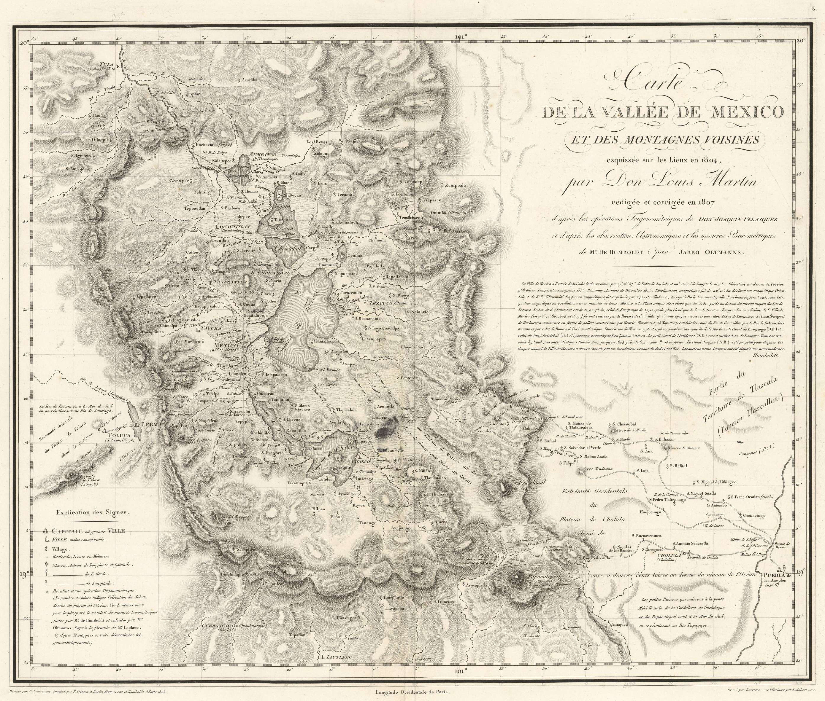
Fig. 4: Alexander von Humboldt. Map of the valley of Mexico and nearby mountains. Biblioteca virtual del Ministerio de Defensa. Spain.
Humboldt’s Atlas included other smaller, partial maps, which we shall only consider briefly. The first represented the nine points that he used to link the Atlantic and Pacific oceans; according to him, the most interesting among these were sketches of the small diversionary canal of Raspadura and the Isthmus of Tehuantepec, and the course of some rivers traced by the engineers Miguel del Corral and Agustín Cramer.
This was followed by a small map of the road from Acapulco to Mexico, carried out by Humboldt between 28 March and 11 April 1803, during his trip to the capital of New Spain. The following page presented three itinerary maps with the Mexico-Durango road through Zacatecas, Durango, Chihuahua, and Santa Fe (Nuevo Mexico). This map was based on Humboldt’s own astronomical observations and Oteyza’s travel diaries. Humboldt warned of possible discrepancies between this map and the general map of New Spain, but he argued that he had chosen not to interfere with the engineer’s observations for this itinerary map. He also represented the road from Durango to Chihuahua, ostensibly taking into account Rivera’s and Mascaró’s observations; the former went directly to Chihuahua but the latter took a diversion through Zacatecas, Fresnillo, La Laborcilla and Abinito; in the end, however, Humboldt’s map was entirely based on Rivera’s observations, except for the latitude of Durango, which he based on Oteyza’s barometric observations. The third map represented the road from Chihuahua to Santa Fe, in Nuevo Mexico, again following Rivera’s diaries and Lafora’s manuscript notes on the region.
The following map represented the eastern regions of New Spain, from the Mexican plateau to the coast of Veracruz, Orizaba, and Xalapa; this was based on Humboldt’s own astronomical observations and those taken by engineers García-Conde and Constanzó in the framework of a military project in 1797. Humboldt measured four large mountains (Popocatepetl, Iztaccihuatl, Citlaltepetl, and Naucampaptepetl), in addition to the positions of Mexico City, Cholula, Puebla, and Xalapa, which enabled him to establish the remaining points. The position of the coast of the Gulf of Mexico was based on José Joaquín Ferrer’s astronomical observations, which Humboldt trusted without hesitation, and on his own barometric measurements.
To this, Humboldt added a complementary map of the wrong positions assigned to Mexico City and the ports of Veracruz and Acapulco13. In this, he followed the model posed by the Mappa critica Germaniae, published in 1750 by the astronomer Tobias Mayer, the inventor of the reflecting circle, who was famous for his Lunar Tables and for perfecting geodesic triangulation. Humboldt also included a plan of Veracruz, owing to this port’s economic and military importance. In fact, this was an exact reproduction of the map made by Bernardo de Orta, captain of this port, from which the treasures of New Spain were shipped to Europe, in 1798. Humboldt writes that he reduced the original scale by half, and added a few notes concerning longitude, wind regimes, atmospheric tides, and rainfall regimes.
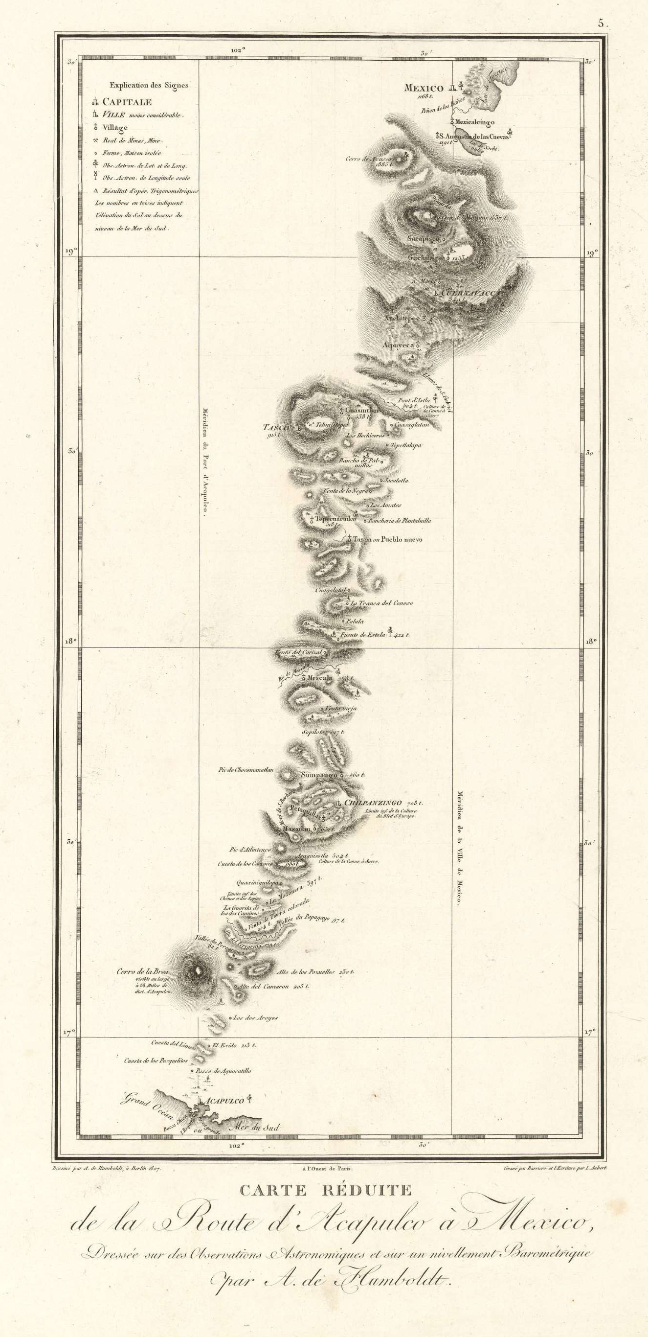
Fig. 5: Alexander von Humboldt. Small map of the road from Acapulco to Mexico. Biblioteca virtual del Ministerio de Defensa. Spain.
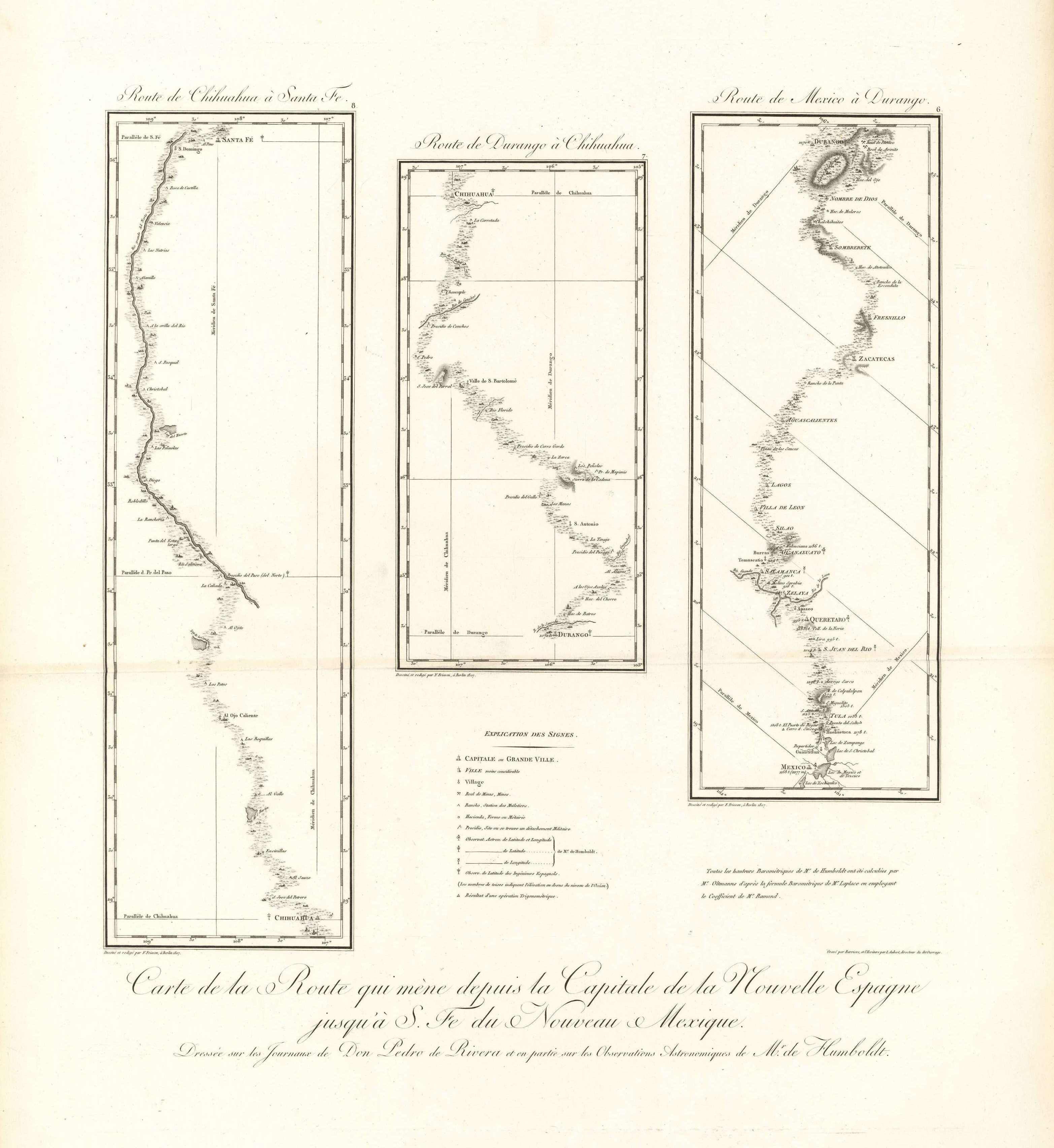
Fig. 6: Alexander von Humboldt. Map of the road from the capital of New Spain to Santa Fe de Nuevo Mexico. Based on Don Pedro de Rivera’s diaries. Biblioteca virtual del Ministerio de Defensa. Spain.
This is followed in the Atlas by a series of truly Humboldtian cartographic profiles. According to Humboldt, these were included because horizontal projections did not adequately account for differences in elevation and the country’s physiognomy. Before this, Humboldt had carried out vertical sections of whole countries, as though was representing a mine or a canal, but taking care to account for scale differences between altitude and distance. Physical maps could only be consistently turned into vertical projections if the points through which the projection plane ran – the three coordinates: the longitude, the latitude, and the elevations above sea level – were known, and if barometric measurements were linked to astronomical observations. This was the method followed in the three sections published in the Atlas; distance-elevation scales followed a 1/24 ratio, and the margins included data about soil geology, altitude boundaries of wheat cultivation, permanent snow lines, and other information of interest. The first plate dealt with the physical section of the eastern slope of the plateau of New Spain; the second with the western slope; and the third with the central Mexican plateau, between 19° and 21° N (the road from Mexico to Guanajuato), drawn in Mexico by Rafael Dávalos, student at the mining school, under Humboldt’s direction. Carmen Manso has analysed these sections and has compared them with those held by the Real Academia de la Historia, Madrid.
The section of the Huehuetoca or Nochistongo canal, dug in the 17th century to prevent flooding in the Mexican capital, is also of interest. According to Humboldt, this section was prepared by Friesen based on the drawings of Ignacio Castera, the architect of hydraulic works in Mexico City, and the scale is too large for the small difference in elevation between Mexico’s central square and lake Tezcuco or Texcoco to show. The distance/elevation ratio also needed correcting, so the canal’s gradient and the tiered nature of the lakes, ultimate cause of the floods that affected the Mexican capital, could be appreciated. Parallel projection plans, in different colours, similar to those used for the course of roads and canals, were also included.
The following plates depict views of the volcanos of Puebla, the Iztaccihuatl, the Popocatepetl, and the Orizaba, as seen from Mexico City. Cortés travelled between the Iztaccihuatl and the Popocatepetl in his first expedition to Mexico City. The original drawings of the Iztaccihuatl and the Popocatepetl were Luis Martín’s, who drew them from the rooftop of the mining school, and the other was Humboldt’s, made in 1804 from the Xalapa-Hutepeque road; they were later corrected by Wilhelm Friedrich Gmelin in Rome.
These are followed by a plan of the port of Acapulco (a key hub for transpacific trade), drawn by navy officers aboard the Descubierta and the Atrevida, under Malaspina’s orders, in 1791. Although several copies of this plan, which was in all probability made in the Depósito Hidrográfico of Madrid, were available in America, it was still unpublished. In the plan, the port was situated to the west of the position established by Humboldt.
The following map, which represents the routes followed by precious metal (gold and silver) between continents, is even more peculiar. Humboldt claims to have made this map during his voyage from Philadelphia to France in 1804.
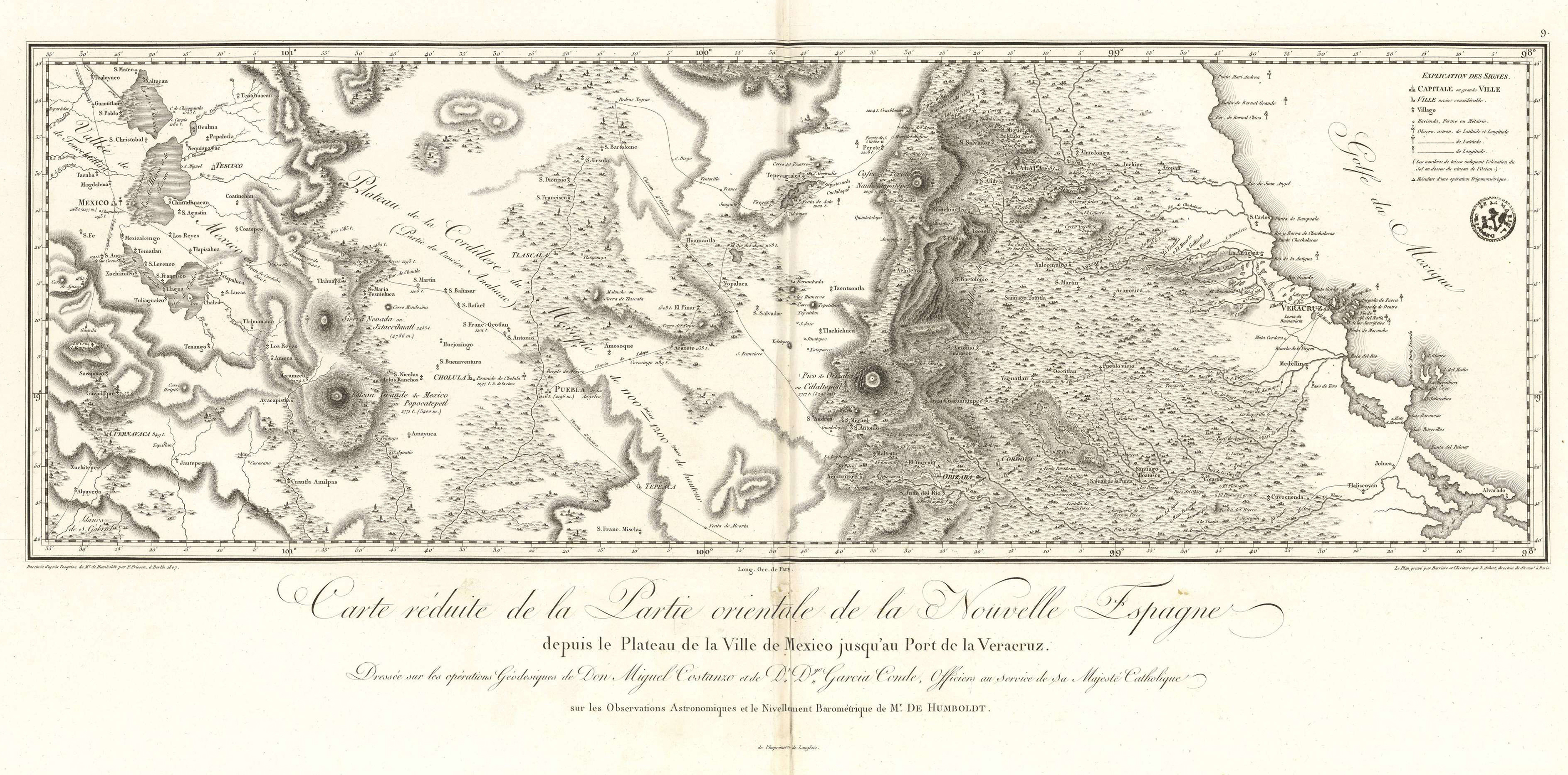
Fig. 7: Alexander von Humboldt. Small map of the eastern region of New Spain, from the Mexico City plateau to the harbour of Veracruz. Based on geodesic observations by Don Miguel Constanzó and Don Diego García Conde, officers of S. M. C. Biblioteca virtual del Ministerio de Defensa. Spain.
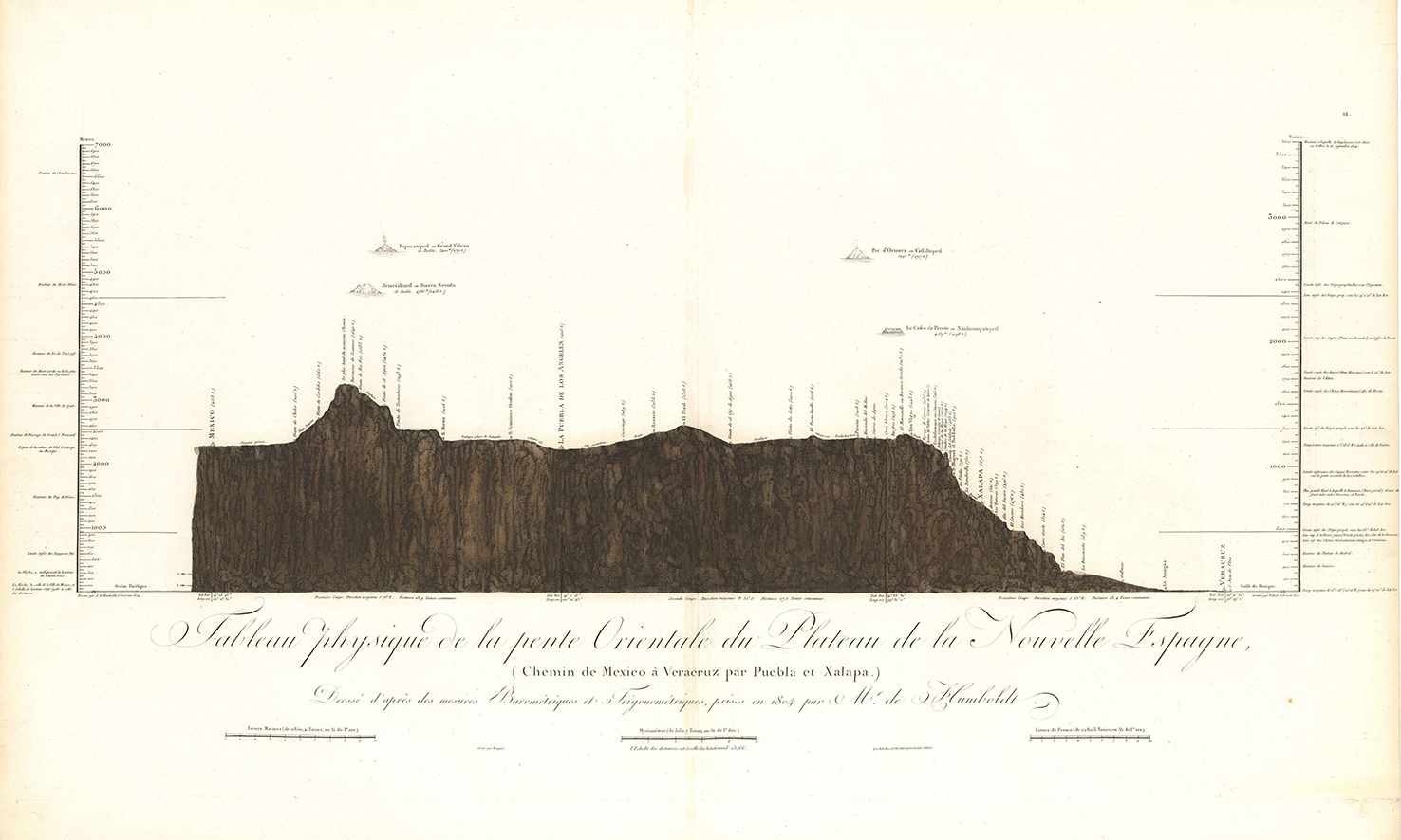
Fig. 8: Alexander von Humboldt. Physical section of the eastern slope of New Spain’s central plateau. Road from Mexico to Veracruz through Puebla and Xalapa. Biblioteca virtual del Ministerio de Defensa. Spain.
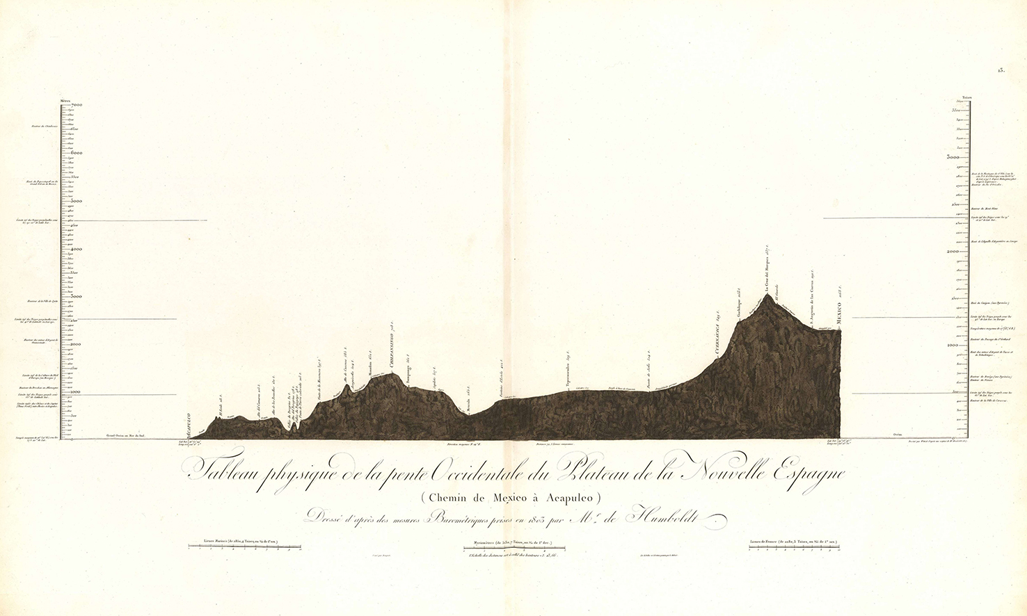
Fig. 9: Alexander von Humboldt. Physical section of the eastern slope of New Spain’s central plateau. Road from Mexico to Acalpulco. Biblioteca virtual del Ministerio de Defensa. Spain.
In the same way, figure XX of the Atlas depicted the surface of New Spain, the intendencias, the progress of mining activities, and other aspects regarding the European colonies in both Indies.
Omar Moncada, an expert in Mexican cartography, argued that Humboldt’s work was highly influential and that his errors spring from his decision to rely on uncertain orographic and hydrographic data rather than guesswork. Humboldt’s most outstanding mistakes, in Moncada’s perspective, were to represent a single mountain range running north to south through the central regions (in the general map), and a mountain range running through central Yucatán (in the map of Mexico and its neighbouring regions).14
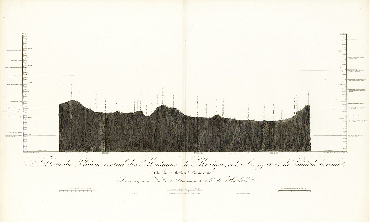
Fig. 10: Alexander von Humboldt. Section of the central plateau of Mexico between 19° and 21° N (road from Mexico to Guanajuato), drawn in Mexico by Rafael Dávalos, student at the mining school, under Humboldt’s supervision. Biblioteca virtual del Ministerio de Defensa. Spain.
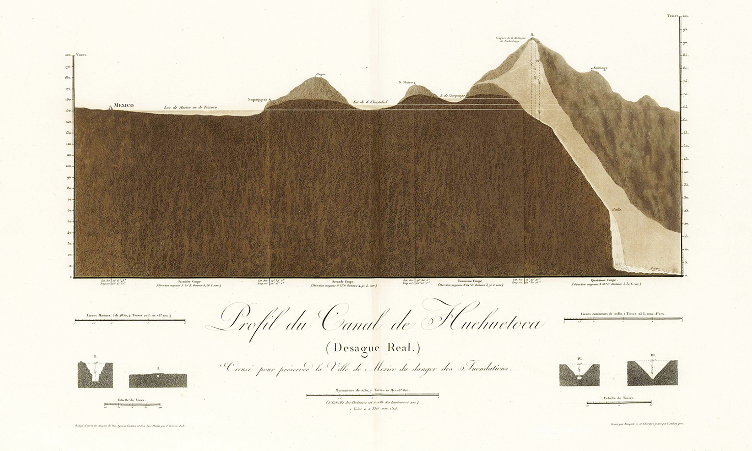
Fig. 11: Alexander von Humboldt. Section of the Huehuetoca Canal (Desagüe Real). Biblioteca virtual del Ministerio de Defensa. Spain.
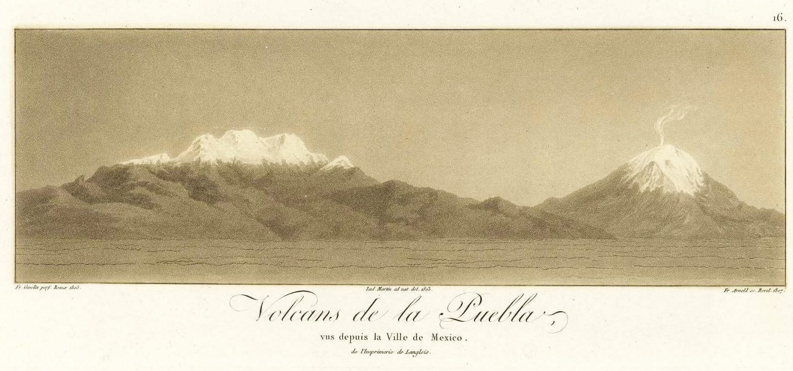
Fig. 12: Alexander von Humboldt. Puebla volcanoes as seen from Mexico City. Biblioteca virtual del Ministerio de Defensa. Spain.
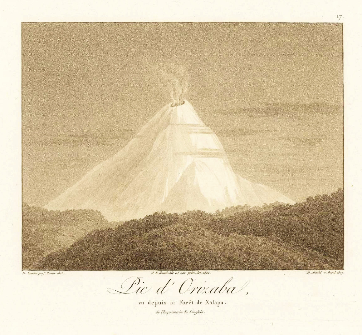
Fig. 13: Alexander von Humboldt. Pico de Orizaba from the Xalapa forest. Biblioteca virtual del Ministerio de Defensa. Spain.
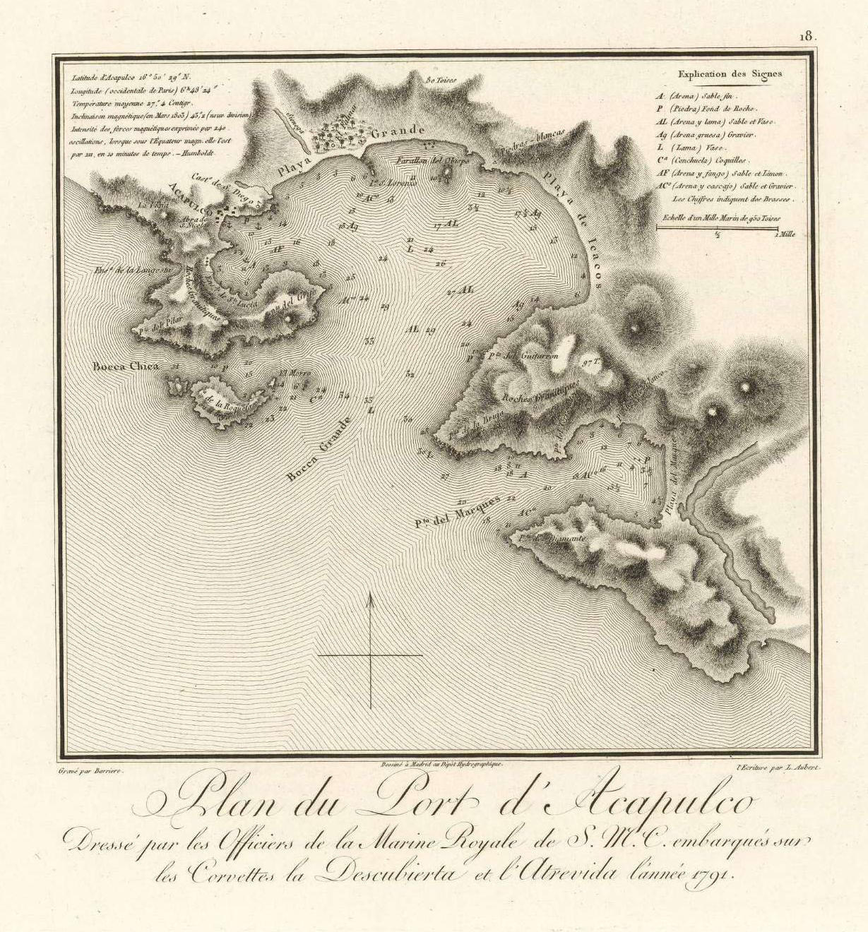
Fig. 14: Plan of Acapulco harbour. Drawn by S. M. C. navy officers aboard schooners Descubierta and Atrevida in 1791. Biblioteca virtual del Ministerio de Defensa. Spain.
Before leaving Mexico, Humboldt dedicated a work to Viceroy Iturrigaray, which he later explained to Charles IV in his dedication of the famous Essai politique sur le Royaume de la Nouvelle-Espagne:
The coasts of America have been surveyed by able astronomers with a munificence worthy of so great a sovereign. Accurate maps of these coasts, and even minute plans of several military positions, have been published at the expense of your Majesty; and you gave orders that there should be annually published in a Peruvian journal at Lima a state of the commerce, finances, and populatioThere was still wanting a statistical essay on the kingdom of New Spain. I digested the great number of materials which I possessed into a work, of which the first sketch drew the attention of the viceroy of Mexico in a manner which redounded to his honour.15
Although the Tablas geográficas políticas del reino de Nueva España, which Humboldt had given to Viceroy José Iturrigaray in manuscript form, arrived at the print soon after, these printed copies stayed in the Mexican capital.16 The cover letter that accompanied the manuscript explained Humboldt’s motivations:
Most Excellent Sir,
Your Excellency, when talking to me about the work that I’ve carried out in this kingdom, hinted your wish for me to present you with information that could be valuable for the Governance of these Dominions. I took this hint as a command, which I have obeyed with the utmost pleasure, since my trips have no purpose but to contribute to the commonwealth and happiness of this region, in which nobody is more interested than Your Excellency.
The attached document contains all my calculations concerning area, population, agriculture, mining, and trade in these vast dominions. I am happy with this work, which I dare dedicate to Your Excellency as a feeble token of my everlasting gratitude, hoping it will not be disagreeable to the Viceroy who, from the first day of his happy Government, has given so much proof of his love for mankind. The area of the Kingdom of New Spain, five times greater than that of the [Iberian] Peninsula, had never been estimated before, owing to a lack of observations. In my drawings and tables, Your Excellency will find the size and political potency of all Intendencias. It is impossible to judge whether a country is well or poorly populated unless its area is known.
Records consulted in the Archbishopric have allowed me to correct the errors in the Count of Revillagigedo’s figures, and deduce those for 1803, when Your Excellency took office. My calculations, based on political Arithmetic, will give Your Excellency the consoling News that the Population of these dominions, which has been underestimated by enemies of the Nation and the Spanish Government, is already over five and a half million.
Most of the materials I’ve used are not available at the viceroyalty’s offices, and that alone would convince me that my work will be of some interest to Your Excellency. Should that be the case, it must be said that the papers were copied in a few days, to spare Your Excellency the toil of dealing with my Prussian handwriting.
I beg Your Excellency to pardon my daring. When I am about to leave these dominions I thought of presenting a final token of my veneration, and the gratitude inspired by Your Excellency’s protection, for which I shall be forever in you debt.
Most Excellent sir
Of Your Excellency
Mexico
3 January 1804
The most loyal servant, kissing Your Excellency’s hand.
Baron von Humboldt
As pointed out by Carmen Manso,17 this essay was Humboldt’s only work in Spanish; it is based on the notes taken from official archives and Mexico’s episcopal records, and was handed over to the viceroy before Humboldt set sail for Europe; he kept one copy. Trabulse suggests that the dissemination of the Tablas was underway before 1804 was over, and even that the historian Carlos María de Bustamante tried to have them published in Diario de Mexico in 1807; ten instalments had been published by the time the project was halted for political reasons. The first edition in French, published between 1808 and 1811, raised public interest in the Tables, and an abridged edition by Mariano de Zúñiga y Ontiveros came out in small format in 1822. In Europe, Humboldt knocked on several doors, thinking that the book could sell well in Britain, but he failed several times to have the work published. In a letter to his friend Marc Auguste Pictet, dated to 3 January 1806, he expressed disappointment and concern that the copy in possession of the Prince of Peace (Manuel Godoy) could end up being published. He floated the possibility of translating the work into French and adding his big map of Mexico, including the 900 mines and administrative boundaries, as well as the map of the valley of Mexico and the sections from Mexico City to the sea.18
Humboldt’s Las Tablas Geográficas was a substantial contribution to the understanding of Mexico’s physical geography, population, and economic resources; they were more concise than the famous Ensayo político sobre la Nueva España,19 a critical and comprehensive perspective on the territory that whetted the appetite of foreign powers for Mexican natural resources and increased the New Spanish elite’s awareness of their own territory in the eve of their independence.20
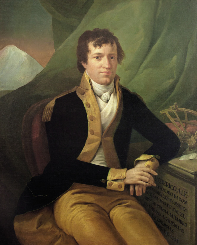
Fig. 15: Rafael Ximeno y Planes, Retrato de Alexander von Humboldt, óleo sobre tela, 1803. Museo Manuel Tolsá, Facultad de Ingeniería-UNAM. Fotografía: Javier Otaola.
Mexico had a peculiar relationship with modernity when Alexander von Humboldt arrived in the country; after glossing the tropical paradise that Latin America was, he stressed that Mexico was a civilised paradise, betraying an eminently Eurocentrist perspective. What he found, in many cases, was a European society which had adopted many traits from the powerful autochthonous culture. Humboldt was critical with the structure of Mexican society; he labelled Mexico as the country of inequality, in which wealth, civilisation, property, and land ownership were distributed most unjustly; there were no middle classes. As he pointed out, in Mexico one could be rich or poor; noble or villainous (this concerned especially the indigenous population), either de facto or de jure. The origin of this inequality, which accentuated the backward, pre-modern features of Mexican society, was according to Humboldt – who in this followed Clavijero – the cultural and political heritage of pre-Hispanic civilisations, exacerbated by quasi-medieval institutions like the encomienda; religious fanaticism, which had enculturated indigenous groups without giving them other outlets for development; the Spanish Crown’s commercial monopoly; and the systematic marginalisation of Creoles from public life, which was a constant source of irritation and resentment. This situation, especially the subordinate position assigned to Creoles – who were beginning to say that they were not Spanish, but American – led Humboldt to denounce the dangers of division, although his writings are those of an Enlightened reformist, not a pro-independence intellectual:
The counterpoint to the backwardness of Mexican society, which was highlighted by social inequality, was the modernity of some of its institutions, and the relatively advanced state of its sciences. Humboldt emphasised that the principles of new chemistry were better known in Mexico than in many parts of the Iberian Peninsula, and that young Mexican men could be found having scientific discussions even in the remotest confines of California.21 Moreover, a number of Mexican scholars gave the lie to the ignorance that European pride blamed the Creoles for, and demonstrated that their alleged apathy and moral slackness was not caused by climate, but by isolation and the lack of modern social institutions. Among these scholars, Humboldt emphasised the figure of José Antonio Alzate, correspondent member of the Paris Academy of Sciences and the Royal Botanical Gardens of Madrid, editor of Gaceta de Literatura, and an influential member of Mexican cultural life; Alzate did not hesitate to confront the naturalists of the Royal Botanical Expedition to New Spain (1787–1803) – directed by Martín de Sessé – pitching autochthonous knowledge against new European scientific paradigms. Humboldt, on the other hand, also praised Peninsular technicians and scholars, such as the engineer Constanzó, who was an important source for him.22
The criticisms levelled against the colonial system in the Ensayo político were to a large extent adopted by post-independence discourses in Mexico and other countries, and are explicitly mentioned, as early as 1813, in Mier’s Historia de la Revolución de Nueva España. However, it does not seem that the Ensayo was received in the metropolis as a particularly critical piece that could endanger the colonial system. In 1818, the Madrid journal Minerva, directed by Pedro María de Olivé, published an extensive section of the work in two volumes, thanked Humboldt for dedicating the work to King Charles IV, emphasised the help that the Spanish had lent to Humboldt’s trip, and praised his ‘universal knowledge’.
José Miranda has analysed the impact of Humboldt’s work in independent Mexico, pointing out that, in an article published in Aguila Mexicana in 1824, the Mexican government argued that Humboldt’s works ‘had helped not a little to kindle the wish for independence of many of Mexico’s inhabitants, waking them from the long torpor into which they had been forced by foreign domination’. Emphasis was laid on Humboldt’s contribution to a better understanding of the geography and wealth of Mexico, a point forcefully stressed by Alamán. According to Miranda, this was not entirely new, as national awareness had sprung before Humboldt’s visit to New Spain, although he admits that his synthesis may have played a part in increasing the self-awareness of Creole elites.23 The incorporation of Humboldt’s work and thought to the national Mexican narrative by post-independence intellectuals has been analysed by José E. Covarrubias,24 based on the critical examination of the Ensayo político undertaken by José Mª Luis Mora in Mexico y sus revoluciones, published in Paris in 1836 – Mora relativised the value of Humboldt’s work as a source to understand Mexico, owing to the profound changes undergone by the country after independence – and on Tadeo Ortiz de Ayala’s Resumen de la estadística del Imperio Mexicano (1822), which questioned Humboldt’s population figures for the first time. Generally, however, Humboldt kept his mythical status in the self-reflection of Mexican thinkers, perhaps because they indirectly identified a better understanding of their country through history and archaeology with political freedom.25
Covarrubias, J. E. (1997). Humboldt y su influencia en el pensamiento político y social mexicano de la primera mitad del siglo XIX. Frank Holl (ed.), Alejandro de Humboldt en México. México: Instituto Nacional de Antropología e Historia-Instituto Goethe, 154–163.
Humboldt, A. von (1804). The Literary Magazine and American register for 1804, Philadelphia, Vol II, pp. 325–326.
Humboldt, A. de (1808). Atlas Géographique et Physique du royaume de La Nouvelle Espagne, fondé sur des observations, des mesures trogonométriques et des nivellemens barométriques. Paris: Chez Fr. Schoell, rue des Fossés-S.-Germain-L’Auxerrois, nº. 29… et al Tübingue, Chez J. G. Gotta Libraire.
Humboldt, A. de (1811). Essai Politique sur le Royaume de la Nouvelle-Espagne. Paris, Chez F. Schoell, 1811, 5 vol. in-8.
Humboldt, A. de (1991). Ensayo político sobre el Reino de la Nueva España. Estudio preliminar, revisión del texto de Juan A. Ortega y Medina. México: Editorial Porrúa. Quinta edición.
Humboldt, A. von (2003). Tablas Geográficas Políticas del Reyno de Nueva España. México: AGN-Siglo XXI editores, coord. por Charles Minguet y Jaime Labastida, 25–31.
Labastida, J. (1975). Humboldt, ese desconocido. México: Secretaría de Educación Pública.
Lafuente Ferrari, E. (1941). El Virrey Iturrigaray y los orígenes de la Independencia de Méjico. Madrid: Instituto Gonzalo Fernández de Oviedo, CSIC.
Lettres d’Alexandre de Humboldt à Marc-Auguste Pictet (1795–1824) (1868). In Le Globe. Revue genevoise de géographie, 7, 129–204, DOI: https://doi.org/10.3406/globe.1868.7016.
Manso, C. (2008). La colección cartográfica de América de Alexander von Humboldt conservada en la Real Academia de la Historia. Boletín de la Real Academia de la Historia, CCV, 3, 537–589.
Miranda, J. (1995). Humboldt y México. México: UNAM, 2ª ed.
Moheit, U. (ed.). (1993). Alexander von Humboldt. Briefe aus Amerika (1799–1804). Berlin: Akademie Verlag.
Moncada Maya, J. O. (1994). El ingeniero Miguel Constanzó. Un militar ilustrado en la Nueva España del siglo XVIII. México: UNAM.
Moncada Maya, J. O. (1997). Humboldt y el desarrollo de la cartografía mexicana. Frank Holl (ed.), Alejandro de Humboldt en México. México: INAH-Instituto Goethe, 67–80.
Moreno, R. (1962). La Ilustración mexicana que encontró Humboldt, Ensayos sobre Humboldt. Mexico: Universidad Nacional Autónoma de México, 217–237.
Ortega y Medina, J. A. (1960). Humboldt desde México. México: UNAM.
Peset, J. L. (1987). Ciencia y libertad. Madrid: CSIC.
Puig-Samper, M. A. (1998). El viajero científico: la visión de Humboldt sobre Nueva España. Salvador Bernabéu Albert (ed.), El Paraíso occidental. Norma y diversidad en el México virreinal. Madrid: Instituto de México en España, 197–211.
Puig-Samper, M. A. & Rebok, S. (2002). Alexander von Humboldt y el relato de su viaje americano redactado en Filadelfia. Revista de Indias, vol. LXII, núm. 224, 209–223.
Real Díaz, J. J. & Heredia Herrera, A. M. (1972). “El Virrey Don José de Iturrigaray”, Los virreyes de Nueva España en el reinado de Carlos IV. Sevilla: Escuela de Estudios Hispanoamericanos del CSIC, 183–331.
San Pío, P. & Puig-Samper, M. A. (eds.). (2000). El Águila y el nopal. Barcelona: Lunwerg.
Serrera, R. M. (2000). Alejandro de Humboldt y las fuentes escritas del Ensayo político sobre el reino de la Nueva España. Chronica Nova, 27, 217–238.
Trabulse, E. (1985). Historia de la Ciencia en México. México: Fondo de Cultura Económica.
Zea, L. y Magallón, M. (comp.). (1999). El mundo que encontró Humboldt. México: Instituto Panamericano de Geografía e Historia-FCE, 1999.
* This publication is part of the Connected Worlds: The Caribbean, Origin of Modern World project. This project has received funding from the European Union’s Horizon 2020 research and innovation programme under the Marie Sklodowska Curie grant agreement Nº 823846. This project is directed by Professor Consuelo Naranjo Orovio, Instituto de Historia-CSIC.
1 Archivo General de Indias (AGI), Diversos, 56, N. 1.
2 Ulrike Moheit (ed.) (1993). Alexander von Humboldt. Briefe aus Amerika (1799–1804). Berlin: Akademie Verlag.
3 Baron Humboldt, The Literary Magazine and American register for 1804, Philadelphia 1804, Vol II, pp. 325–326. Miguel Ángel Puig-Samper, M. A. & Sandra Rebok (2002). Alexander von Humboldt y el relato de su viaje americano redactado en Filadelfia. Revista de Indias, vol. LXII, núm. 224, 209–223.
4 Ramón Serrera (2000). Alejandro de Humboldt y las fuentes escritas del Ensayo político sobre el reino de la Nueva España. Chronica Nova, 27, pp. 217–238; Enrique Lafuente Ferrari (1941). El Virrey Iturrigaray y los orígenes de la Independencia de Méjico, Madrid: Instituto Gonzalo Fernández de Oviedo, CSIC; José Joaquín Real Díaz & Antonia M. Heredia Herrera (1972). “El Virrey Don José de Iturrigaray”, Los virreyes de Nueva España en el reinado de Carlos IV, Sevilla: Escuela de Estudios Hispanoamericanos del CSIC, pp. 183–331.
5 Roberto Moreno (1962). La Ilustración mexicana que encontró Humboldt, Ensayos sobre Humboldt. México: Universidad Nacional Autónoma de México, pp. 217–237.
6 Baron Humboldt, The Literary Magazine and American register for 1804, pp. 326–327.
7 Atlas Géographique et Physique du Royaume de la Nouvelle Espagne (Paris, Chez FR. Schoell, 1808). In: http://bibliotecavirtualdefensa.es/BVMDefensa/es/consulta/registro.do?id=82597. The 1811 edition is available at https://www.davidrumsey.com/luna/servlet/s/4cpneq.
8 Alexander von Humboldt, Political Essay on the Kingdom of New Spain, London, vol. I, 1811, p. Ii.
9 Carmen Manso, La colección cartográfica de América de Alexander von Humboldt conservada en la Real Academia de la Historia. Boletín de la Real Academia de la Historia, CCV, 3, 2008, pp. 537–589.
10 Alexander von Humboldt, Political Essay on the Kingdom of New Spain, London, vol. I, 1811, pp. xx–xxi.
11 Alexander von Humboldt, Political Essay on the Kingdom of New Spain, London, vol. I, 1811, pp. xxviii–xxix.
12 Tobias Kraft (2019). El valle de Anahuac. Zur politischen Semantik der Humboldt’schen Kartographie. In: David Blankenstein, Bénédicte Savoy, Raphael Gross, Arnulf Scriba (eds.): Wilhelm und Alexander von Humboldt. Darmstadt: Wissenschaftliche Buchgesellschaft, pp. 191–197.
13 Rayfried Lionel Stevens-Middleton. La obra de Alexander von Humboldt en México. Obra publicada en colaboración con la [sic] Sociedad Mexicana de Geografía y Estadística. Ciudad de México: Instituto Panamericano de Geografía e Historia 1956 (Publicación No. 202), pp. 62 y ss.
14 J. Omar Moncada Maya (1997). Humboldt y el desarrollo de la cartografía mexicana. Frank Holl (ed.). Alejandro de Humboldt en Mexico. Mexico: INAH-Instituto Goethe, pp. 67–80.
15 Alexander von Humboldt, Political Essay on the Kingdom of New Spain, London, vol. I, 1811, pp. xvi–xvii.
16 Alexander von Humboldt (2003). Tablas Geográficas Políticas del Reyno de Nueva España. México: AGN-Siglo XXI editores, coord. por Charles Minguet y Jaime Labastida, pp. 25–31.
17 Carmen Manso (2008). La colección cartográfica de América de Alexander von Humboldt conservada en la Real Academia de la Historia. Boletín de la Real Academia de la Historia, CCV, 3, pp. 537–589.
18 Lettres d’Alexandre de Humboldt à Marc-Auguste Pictet (1795–1824) (1868). In Le Globe. Revue genevoise de géographie, 7, pp. 129–204. DOI: https://doi.org/10.3406/globe.1868.7016.
19 Alexander von Humboldt (1991). Ensayo político sobre el Reino de la Nueva España. Estudio preliminar, revisión del texto de Juan A. Ortega y Medina. Mexico: Editorial Porrúa. Quinta edición.
20 Miguel Ángel Puig-Samper (1998). El viajero científico: la visión de Humboldt sobre Nueva España. Salvador Bernabéu Albert (ed.), El Paraíso occidental. Norma y diversidad en el Mexico virreinal. Madrid: Instituto de Mexico en España, pp. 197–211.
21 Elías Trabulse (1985). Historia de la Ciencia en Mexico. Mexico: Fondo de Cultura Económica.
22 José Luis Peset (1987). Ciencia y libertad. Madrid: CSIC; Pilar San Pío, & Miguel Ángel Puig-Samper (eds.). (2000). El Águila y el nopal, Barcelona: Lunwerg; J. Omar Moncada Maya (1994). El ingeniero Miguel Constanzó. Un militar ilustrado en la Nueva España del siglo XVIII. Mexico: UNAM.
23 José Miranda (1995). Humboldt y México. México: UNAM, 2ª ed.
24 José Enrique Covarrubias (1997). Humboldt y su influencia en el pensamiento político y social mexicano de la primera mitad del siglo XIX. Frank Holl (ed.). Alejandro de Humboldt en México. México: Instituto Nacional de Antropología e Historia-Instituto Goethe, pp. 154–163.
25 Leopoldo Zea y Mario Magallón (comp.) (1999). El mundo que encontró Humboldt. México: Instituto Panamericano de Geografía e Historia-FCE, 1999. Jaime Labastida (1975). Humboldt, ese desconocido. Mexico: Secretaría de Educación Pública.

Dieses Werk steht unter der Lizenz Creative Commons Namensnennung - Nicht-kommerziell 4.0 International.
HiN - Alexander von Humboldt im Netz wird herausgegeben von der Universität Potsdam und der Berlin-Brandenburgischen Akademie der Wissenschaften.
ISSN 1617-5239 (online)
ISSN 2568-3543 (print)