Jörn Seemann
Though Humboldt’s travels to the Americas have been analyzed from a wide range of viewpoints, there are specific aspects that still await further investigation. Little is written about Humboldt in the field, specifically how he moved between different locations and simultaneously measured and mapped places and phenomena. The aim of this article is to discuss the triad movement-measurement-map that led to the development of specific practices of knowledge building on the move. Humboldt’s search for the connections between the watersheds of the Orinoco and the Amazon rivers and the resulting maps and drawings are used as an example to point out his cartographic impulse in his quest to understand and explain the physical world.
Obwohl Humboldts Reisen nach Amerika unter verschiedenen Gesichtspunkten analysiert wurden, gibt es bestimmte Aspekte, die noch weiter untersucht werden müssen. Wenig ist jedoch über Humboldt im Feld geschrieben, insbesondere darüber, wie er sich zwischen verschiedenen Orten bewegte und gleichzeitig Lokalitäten und Phänomene maß und kartierte. Das Ziel dieses Artikels ist es, die Triade Bewegung-Messung-Landkarte zu diskutieren, die zur Entwicklung spezifischer Praktiken des „Wissenschaffens“ in Bewegung führte. Humboldts Suche nach den Verbindungen zwischen den Wassereinzugsgebieten des Orinoco und des Amazonasflusses sowie die daraus resultierenden Karten und Zeichnungen dienen als Beispiel, um seinen kartografischen Impuls bei seinem Bestreben, die physische Welt zu verstehen und zu erklären, hervorzuheben.
Aunque los viajes de Humboldt a las Américas han sido analizados desde una amplia gama de puntos de vista, hay aspectos específicos que aún esperan una mayor investigación. Poco se escribe sobre Humboldt en el campo, específicamente cómo se movió entre diferentes lugares y simultáneamente midió y cartografió lugares y fenómenos. El objetivo de este artículo es discutir la tríada movimiento-medición-mapa que condujo al desarrollo de prácticas específicas de construcción de conocimiento en movimiento. La investigación de Humboldt de las conexiones entre las cuencas hidrográficas del Orinoco y del Amazonas y los mapas y dibujos resultantes se utiliza como un ejemplo para señalar su impulso cartográfico en su búsqueda para comprender y explicar el mundo físico.
On June 5, 1799 the corvette Pizarro left the Northwestern Spanish port of La Coruña on its way to the Americas. Aboard were Alexander von Humboldt and his French travel companion Aimé Bonpland. They embarked on a five-year journey through Spanish Latin America to explore, measure and map little known places, collect samples from the regional flora and fauna and gather data that would help to elucidate the natural history of the world and the physical description of the universe. The legacy of Humboldt’s travels is a vast collection of animal and plant specimens and dozens of books and more than 800 scientific essays and articles on his observations and experiences during his travels. Among the most insightful geographical works are his personal narratives based on his travel diaries that were almost simultaneously published in French, German and English (Humboldt 1814–1825, 1814–1829, 1815–1832) and his Atlas Géographique et Physique des Régions Équinoxiales du Nouveau Continent (Humboldt 1814–1834).1
Unfortunately, Humboldt never wrote his autobiography, though he has been studied by a large number of biographers.2 His substantial personal correspondence and the accounts by scholars and acquaintances from his own vast network are the only sources to learn more about Humboldt’s personality (e.g. Humboldt 1860; Moheit 1993). Paintings showing the German scholar in imaginary scenes of exotic landscapes (for example, the Amazon forest or the Andean plains) and in his library are the few visual records of him.
Despite the “literary cosmos”, that surrounds the German naturalist, not much is known about “Humboldt in action.” How did he work in the field? How can we imagine Humboldt moving in space, making measurements and mapping the physical world? His dry scientific notes do not reveal much about his personality, and his writings transmit the image of a solitary scientist facing the challenges of dense forests, streams, and mountains, without mentioning that he had travel companions and a large cohort of native people to carry his equipment and baggage. Humboldt’s travel descriptions do not reflect his mobility and restlessness as a compulsive observer. He did not only write about space in the sense of the physical environment that he described, but he was also physically in space, this is, as a traveler he cannot be separated from the landscapes and places that he experienced. His travelogues represent “literature on the move” in the sense that “processes of thinking and writing are based on a multitude of movements that are aimed not so much at space, but rather at overcoming space” (Ette 2003, 17). Consequently, writing about space (i.e., the places he explored) and the writing space itself (written pages of his books, letters and diaries) are inseparable and essential for the understanding of historic travelers and their motivations, thoughts, decisions and values. The simultaneous consideration of thought and body generates mobilities of knowledge that operate in two interrelated spheres. They are, at the same time, “geographical mobilities for knowledge in the process of its production and of knowledge as part of its dissemination and transfer, while stressing that geographical and epistemological movement across different places and fields of knowledge are closely intertwined” (Jöns, Heffernan and Meusburger 2017, 2; emphasis in original). The naturalist, scientist and traveler as a restless agent of collecting, analyzing and disseminating information exercises a very important role in the production of knowledge on the move.
In this context, the aim of this essay is to present further insights into Humboldt’s knowledge-building movements and moments that entail, simultaneously, observations and writing while traveling between places. I will give special emphasis to his mobility, measurement and mapping practices. This text consists of three parts: In the first section, I will provide a brief outline of Humboldtian science, pointing out the principles that guided him in his studies. His cartographic impulse is the topic of the second part, which is also the starting point for the third section, Humboldt’s visual ideas about the borderlands between Spain and Portugal and the Casiquiare Canal (the connection between the watersheds of the Amazon and Orinoco) before, during, and after his journey.
This essay does not only seek to contribute to the substantial literature on the German naturalist, but also to initiate a debate on the three M’s mentioned in the title of this paper. These reflections are not restricted to Humboldt, but should also serve as a model that can be used for the study of other travelers/scientists.3 Movements, measurements and mapping practices should not be conceived as a sequence of actions or separate practices, but as interactions and performances that have characterized scientific travels during the last five centuries.
In the introduction to his Personal Narrative, Alexander von Humboldt eagerly shared with his readers how he defined the idea of happiness for a naturalist and explorer. He wrote: “Happy the traveller who is conscious that he has availed himself of the advantages of his position and that he has added some new facts to the mass of those which were already acquired!” (Humboldt 1814, xlvi). The German scholar barely suppressed his enthusiasm about literally “measuring the world,” from air pressure and temperature to mountain heights, sky color and the voltage of electric eels—part of his essential daily routines on his America journey. Humboldt not only aimed to explore unknown places and measure their configurations and correlations, but he also desired to verify and, if necessary, correct the measurements done by other scientists who traveled to and through the region. He set two major aims for his travel:
I wished to make known the countries I had visited; and to collect such facts as are fitted to elucidate a science, of which we have possessed scarcely the outline, and which has been vaguely denominated natural history of the world, theory of the Earth, or physical geography (Humboldt 1814, iii, original emphasis).
The latter purpose, the collection of facts to contribute to science, was an absolute priority for the German scholar. His concerns with the how and what of measurements became a permanent concern or even an obsession. Humboldt’s conception of science, and then Humboldtian science urged
[t]he terrestrial physicist (…) to carry and care for a remarkable array of precise instruments to measure everything from the passage of time (chronometers) and the angular distances of stars, satellites, and landmarks (telescopes, quadrants, sextants, a repeating circle, a theodolite). The direction and intensity of magnetism (dip needles and magnetic compasses), to the temperature (thermometers), humidity (hygrometers), pressure (barometers), electrical tension (electrometers) and chemical composition (eudiometers) of the atmosphere (Dettelbach 1996, 289).
Humboldt’s impact and influence on science and its methods reached such an extent that scholars in the field use the term Humboldtian science today, classifying his research methods as a genre by itself. The expression was originally coined and defined by the American historian of science Susan Cannon who conceived it as scientific proceedings that include “astronomy and the physics of the earth and the biology of the earth all viewed from a geographical standpoint, with the goal of discovering quantitative mathematical connections and interrelationships” (Cannon 1978, 77). By “quantitative mathematical” Cannon meant to say that Humboldt had an obsession with measurements, not only his own, but also those done by other scientists. Bluntly put, “he measured accurately what explorers had reported inaccurately” (Cannon 1978, 75). It may be contestable to call this behavior a form of arithmomania, the obsession of counting, ranking and classifying everything in one’s immediate range. However, Humboldt accepted his measurements as a daily routine ritual, for example, determining temperatures, air pressure and humidity every day at the same time or observing the stars to find out about geographical positions whenever the weather conditions allowed it. In her somewhat ironic reflections on Humboldtian science, Cannon attributes an almost religious character to Humboldt’s scientific practices and concludes: “Humboldt’s creed was measurement; and having cleared his conscience by repeating this creed for the reader, he then relaxed and enjoyed his profane love, speculation” (Cannon 1978, 80).
His passion for accurate numbers went so far that his diaries and travelogues were filled with data on quantifiable physical phenomena. He even published one separate 600-page volume of calculations with sparse explanations in French, with the support of the East Frisian mathematician Jabbo Oltmanns (1783–1833), containing his “astronomical observations, trigonometric operations, and barometric measurements” during his America journey (Humboldt and Oltmanns 1808). Oltmanns’ task was to verify the precision of Humboldt’s measurements of latitude and longitude, humidity, air pressure and other details and make the necessary corrections. Figure 1 shows the analysis of the data for the Culimacari (Curimacare) rock on the route along the Casiquiare Canal, measured by Humboldt on May 11, 1800. Latitude was determined by the position of the Southern Cross. For the measurement of time (détermination du temps), Humboldt used the star system Alpha Centauri in the sky as reference. The results did not provide a trustworthy longitude for the Curimacare Rock, leading Oltmanns to the conclusion that “[i]t seems that some error has crept into this part of Mr. Humboldt’s manuscript” (p. 240).
Humboldt’s literal number crunching and strong interest in quantitative data may be based on his background as “administrator of state economic matters” that sparked his interest in quantitative measurements (Cannon 1978, 82). His conception of science was essentially physical, but these principles were also applied to human phenomena and processes. For example, Humboldt, as many other naturalists in the 19th century, was quick to make problematic analogies between temperature charts and population statistics or astronomic observations and political economy.
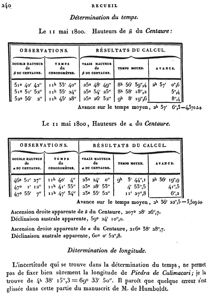
Fig. 1: Page from Humboldt and Oltmanns’ Recueil d’Observations Astronomiques, d’Opérations Trigonométriques et de Mesures Barométriques (Humboldt and Oltmanns 1808, 240)
The more measurements the more input to explain the universe, since “without more detailed first-hand observations, you don’t have a case” (Cannon 1978, 81). In order to achieve these aims, Humboldt needed instruments and devices that allowed him to measure and quantify phenomena with the highest possible precision.
In the first volume of his Personal Narrative, Humboldt provides a detailed, six-page list of all the physical and astronomical instruments that he took on his journey to the Americas. It can be said that Humboldt may even have established a sentimental attachment to his equipment (de Terra 1955, 90), as is shown by how he describes his equipment. Among the more than 30 items (Humboldt 1814, p. 33–39) on board of the Pizarro were instruments such as a chronometer, telescope, sextant, quadrant, magnetometer, compass, barometers, thermometers, hygrometers, an electrometer (to determine the electricity of the atmosphere), a cyanometer (to compare the color of the sky in different places), standard meter, surveyor’s chain, an analytical balance, rain gauge and tubes of absorption (to indicate the presence of carbonic acid and oxygen). The instruments are not generic equipment, but were purchased from the inventors themselves. A dip needle to measure the angle between the horizon and the Earth’s magnetic field was ceded by the French Bureau des Longitude, Humboldt’s eudiometer (to measure traces of nitrous gas in the air to determine its purity) is the model invented by the Italian physicist Felice Fontana (1730–1805), and his timekeeper was previously owned by the French mathematician and sailor Jean-Charles de Borda (1733–1799). Humboldt also liked to compare the precision of the instruments (Dettelbach 1996, 289). In the case of the Fontana eudiometer, he mentioned that it was a better choice than Alessandro Volta’s eudiometer, which, “though the most exact of any, is embarrassing for travelers, who traverse damp countries, on account of the small electric discharge, which the inflammation of oxygen and hydrogen gasses required” (Humboldt 1814, 38). Humboldt was apparently concerned about his safety as a user of the instrument.
Humboldtian science is far more complex than what is described above. Looking further into his complex scientific personality, there are at least ten overlapping and interrelated dimensions that characterize Humboldt as an explorer, scientist and writer (Ette 2018, 106–112). Besides its transdisciplinary, transareal (transregional), cosmopolitan, intercultural nature as a life science that aimed to popularize and democratize science and its respective politics, Humboldt’s scientific conceptions also emphasized the power of communication networks with and among scholars and the diversity and creativity of data visualization, modeling and structuring information. In addition to this, his approach was fractal and inter and trans medial, this is, his peculiar forms of writing and annotations and the arrangement of his visual material are not linear and conventional, but based on archipelagic, discontinuous and relational techniques that corresponds to “a fractal geometry of writing like the model building in science in general” (Ette 2018, 110). For example, drawings and maps in his Vue des Cordilleres (Humboldt 1810–1813) are “telescoped” to visualize the relation between the supposed chaos and fragmentation and the order of the cosmos (p. 110). This fractal aspect is supported by the aesthetics of a creative and visual “mediality” that consists of forms of knowledge presentation and transmission that combine text and images, a pre-computer-age form of visual thinking (Godlewska 1999). Besides Ette’s ten Humboldt characteristics mentioned above, an insatiable curiosity pushed the German naturalist into a restless quest for knowledge and triggered his geographical imagination (Gade 2011). In other words, Humboldt’s curiosity was not a usual form of knowing the world. His thirst for knowledge was not
[a]bout the kind of curiosity that invites but about the kind that demands, not about the kind that says I wonder but the kind that says I must know. The kind that makes you immerse yourself in a subject, ponder it over and over until you are able to make sense of it for others (Harvey 2000, 174–175, emphasis in original).
Another virtue that could be included on the list of Humboldtian dimensions and aspects is Humboldt’s preparedness for any kind of situation, from cloudy skies that prevented him from determining geographical coordinates to his frustrated attempts to fend off mosquitoes: “Thus the complete Humboldt traveler, in order to make satisfactory observations, should be able to cope with everything from the revolutions of the satellites of Jupiter to the carelessness of clumsy donkeys” (Cannon 1978, 76).
The main focus of Humboldt’s studies was on his scientific investigations and achievements, not on his lived experience, though occasionally he weaves in episodes, anecdotes and opinions, e.g., how the mosquitoes bothered him or what he thought about the indigenous people in the Amazon (for example, Humboldt 1821, 93–94 and 430–431). Both his published travel accounts and his personal diaries, which the reader would expect to be more insightful with regards to his personality, are analyses by hindsight and rigorously scientific descriptions that do not correspond to the definition of a diary in a strict sense. In other words, it is not:
a journal kept day-by-day, but rather an informed reading of notes taken during a voyage, carefully edited toward a specific end. We can clearly read the scientific goal of showing nature as an immense and complex machine that can be disassembled and completely understood. (…) We might say that on his voyage he is riding (sic) a previous text. He travels to correct the deficiencies in the Enlightenment view of “America.” His tendency is clearly encyclopedic (Pérez-Mejia 2004, 47–48).
Unfortunately, Humboldt’s diaries are a messy “throwntogetherness”—alluding to Massey’s (2005) idea of time/space/human/non-human negotiations. The entangled, non-linear structure of his daily notes makes their reading more difficult, but curiously, at the same time, the diary pages are similar to interwoven webpage maps, where a click on a link takes the reader to the next item, permitting simultaneous readings.4. Humboldt’s diaries or Tagebücher were not a historical account of what he did in the past, but a work in progress that he updated and, possibly, hoped to be read by posterity after his death in 1859. As a collection of measurements, direct observations and scientific commentaries by others, the diaries are engrafted with transcriptions from other manuscripts and printed matters and mingled with loose notes, some of them in envelopes. The page numbering is not straightforward. Humboldt did not necessarily open the diaries at the beginning of the volume, but occasionally added notes in unexpected places (Engelmann 1970, 6; Leitner 2019). This messy appearance may contradict Humboldt’s sense of organization and systematization at first glance, but at the same time, it shows that his framework of ideas and streams of thought are interrelated in a complex and deep way.
In recent years, scholars have paid more attention to the cartography in Humboldt’s work (Kraft 2014; Ette 2015; Guest 2017; Buchholz 2020). For Humboldt, maps played an important role in his investigations, because they helped him not only to locate places and calculate distances, but also to correlate phenomena, even in places that he did not visit. Humboldt was very quick to point out mismeasurements, incorrect or inaccurate values, and wrong deductions. Figure 2 shows a page from his diary, in which he lists the data to calculate the coordinates of locations along the Casiquiare Canal in present-day Venezuela.5 Following the title “observ. Astronom.”, Humboldt mentions that he made a “beautiful observation” (belle observ.) on “May 11, 1800” or, according to the French Republican calendar, the “21st Floréal, year 8”, standing on the Culimacari (Curimacare) rock, four minutes north from the mouth of the Pacimona (Pacimoni) river. The measured latitude of 1°59'48''N comes very close to the correct value, which is approximately 1°59'54.9''N. Humboldt’s books, diaries and loose notes are peppered with numbers and annotated coordinates like these that he verified (or even corrected) after his return to Europe and that he used for the compilation of maps.
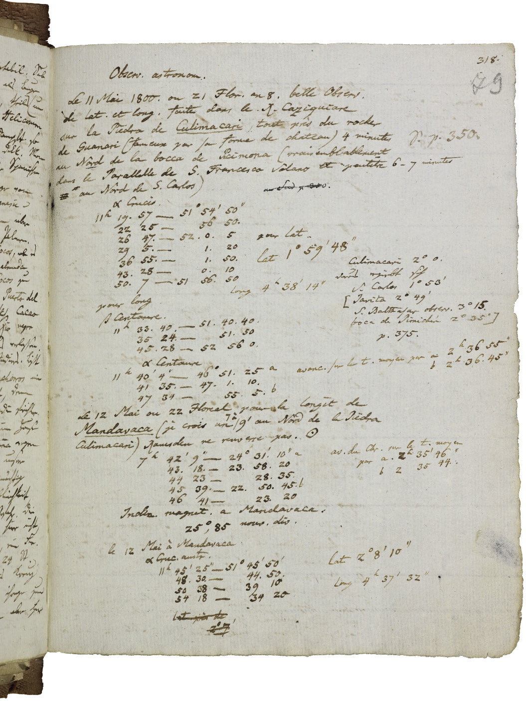
Fig. 2: Page from Humboldt’s travel diaries containing astronomic observations (Humboldt Diaries IV, page 79r, Staatsbibliothek zu Berlin)
A prominent example of Humboldt’s measurement obsession can be found in his Atlas Géographique et Physique du Royaume de la Nouvelle-Espagne (Humboldt 1811). The map that refers to Humboldt’s mapping and surveying is not his well-known general map of Mexico at a scale of 1:3,000,000, printed in two parts from 16° to 38° of latitude North on two large folio sheets and based on Humboldt’s own astronomic observations and the assemblage of existing material in 1804. It is a far less remarkable cartographic rendering. The Carte des Fausses Positions de Mexico, Acapulco, Veracruz et du Pic d’Orizaba shows the incorrect positions of the three Mexican towns and the volcano in an otherwise blank map of the country (figure 3). Humboldt only outlines the coastlines to the Pacific and the Gulf of Mexico and indicates the supposedly correct location of towns in capital letters. According to Humboldt, the longitude of many positions from previous surveys were located too far to the west. An extreme case is Acapulco, whose location bizarrely ends up away from the coast deep in the Pacific Ocean. Alzate (Carta de Mexico), Jean Baptiste D’Anville, Jean Covens and Arrowsmith located the Pacific coast town considerably further to the west than its real longitude. It must be mentioned that Humboldt’s own measurements were not always correct. In a recent cartometric study, Allen (2014) drew the conclusion that Humboldt’s Mexico map was “considerably more accurate than those of either of his predecessors in central Mexico, but that positions in other areas do not generally show great improvements, and in a few cases are even worse” (Allen 2014, 87).
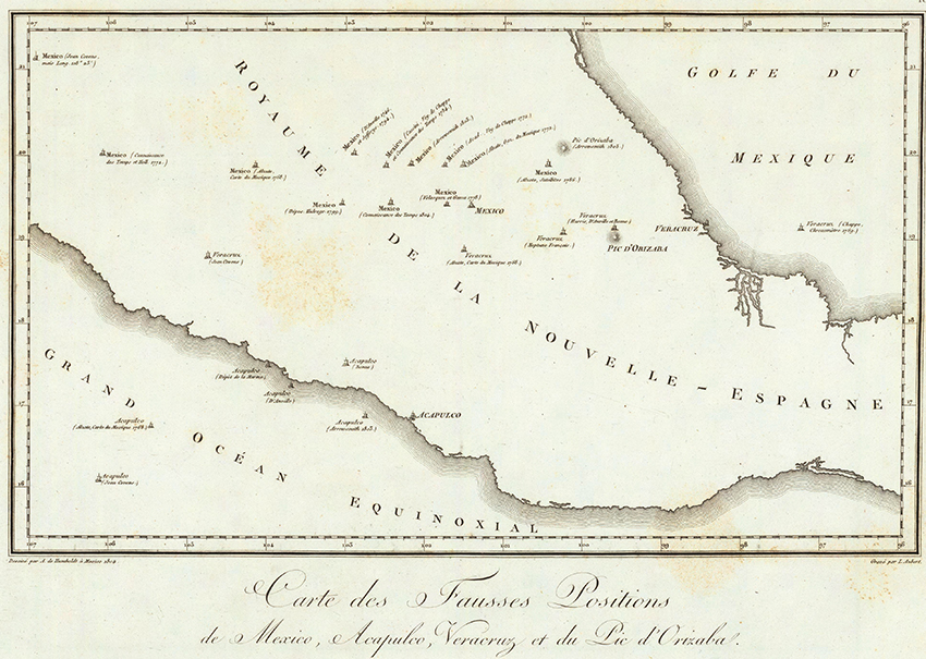
Fig. 3: Carte des Fausses Positions de Mexico, Acapulco, Veracruz et du Pic d’Orizaba (David Rumsey Collection)
Humboldt did not travel to the Americas to make measurements for the sake of measurements. He was not looking for information to confirm theories and create new models and hypotheses about the physical world, but he frenetically collected information, made observations and wrote down numbers to gain a deeper understanding of the universe, based on the idea of an empirical science, “the only ground, on which I know to move less insecurely” (Humboldt 1845, 68).6 South America served him as an open-air laboratory to find answers. He prepared himself for his journey by reading any kind of reference literature that sparked his interest and was particularly intrigued by the story of a river whose waters were flowing in two different directions: the Casiquare Canal, an almost mythological link between the watersheds of the Orinoco and the Amazon River. Humboldt decided to verify the course of this stream in person and look for alternative portage or river routes. In order to achieve his aims, Humboldt became an indefatigable “mapper.” He observed and registered any phenomenon or detail that he stumbled into or that called his attention, was in his range, or contributed to his universal picture of the world. Besides his inquisitive spirit and almost insatiable curiosity, Humboldt added one more dimension to his idea of mapping: the correlation and visualization of information, a way of seeing or a form of visual thinking “that would encourage both conceptual depth and rigor and holistic vision” (Godlewska 1999, 239).
By employing the term “mapping impulse” to describe Humboldt’s mapmindedness, I am making an analogy to 17th-century Dutch painters like Johannes Vermeer and Pieter de Hooch, whose aim it was to:
capture on a surface a great range of knowledge and information about the world. They too employed words with their images. Like the mappers, they made additive works that could not be taken in from a single viewing point. Theirs was not a window on the Italian model of art but rather, like a map, a surface on which is laid out an assemblage of the world (Alpers 1983, 122, my emphasis).
The idea of assemblage of the world may be an adequate term to describe and define Humboldt’s quest for a vision of Cosmos, combining all the different physical aspects of the world in a universal natural history. A fundamental first step for this endeavor was the determination of positions through the measurement of their coordinates. In a conversation with the German cartographer Heinrich Berghaus (1797–1884) on January 2, 1852, Humboldt chided the German explorer Heinrich Barth (1821–1865), whose travel accounts from Africa were lacking any useful measurements for the location of places. On the one hand, he praised Barth’s “iron endurance of not losing a determined aim from his sight,” his knowledge of African culture and his diplomatic skills that gained him the trust of native leaders, and his physical persistence to cope with the extreme climate of the backlands (Humboldt and Berghaus 1863, 209). On the other hand, and despite emphasizing these virtues, Humboldt is quick to come to the weak point of Barth’s explorations: “Pity, eternal pity … that Barth does not understand anything of the first fundament of earth description, the localization of places. Due to this scientific shortcoming, the geography of Central Africa suffers a great loss of positive facts” (Humboldt and Berghaus 1863, 209). Humboldt admitted that he himself was not knowledgeable about measurement tools and methods at the beginning of his career. He had to push himself into learning about the use of instruments for his journey to the Americas to acquire essential measurement skills. Barth’s travel routes, however, remained imprecise and unclear to Humboldt who openly laments:
If he only had come to the idea to put a stick into the ground at noontime in order to measure the shadow of it, as the far less educated Callié [French explorer, 1799–1838] did in a clever way in Timbuktu, one would have a reference, though even still crude, for the altitude at the pole [astronomical latitude] at least” (Humboldt and Berghaus 1863, 210).
Humboldt’s conclusion is that maps must always be the starting point for orientation and location: “It has always been my maxim: first a map, based on reliable observations so that one can orient oneself” (p. 210–211).
With this personal mapping impulse, Humboldt almost resembles the image of the knight-errands evoked by Cervantes’ Don Quixote who do not contemplate the world from their armchair or desk, but literally experience the ground they tread on:
courtiers, without crossing the threshold of their own apartments, travel over the world, in maps, gratis, and never know what it is to suffer either heat, cold, hunger, or thirst, in their journey; whereas, we real knights-errant measure the whole globe with our own footsteps, exposed night and day, on horseback, and a-foot, to the summer’s sun and winter’s cold, and all inclemencies of the weather (Cervantes Saavedra 1833, 206).
Different from armchair geographers like Carl Ritter or travelers of his time who only were in search of curiosities and adventures, Humboldt was able to unite these different postures in one person, resulting in his capacity to continuously and simultaneously theorize and put into practice and document and visualize his findings.
I will use Humboldt’s cartographic production and imagination about the borderlands between the Spanish and Portuguese territories in South America to reflect on his mapping practices before, during, and after his continental journey that started on July 16, 1799 in Cumaná on the Venezuelan coast and took him to the Amazon, Cuba, Colombia, Ecuador, Peru and Mexico, before his return to Europe from Philadelphia on July 9, 1804 (figure 4). As a meticulous scientist, Humboldt made sure that he consulted as many written accounts, scientific treatises and maps as possible before he embarked on his journey to the Americas so that he was able to gain an overview about what to expect in situ. Reaching the region between the Orinoco and Amazon River basins, he fact-checked and corrected geographic positions and cartographic errors and added new details while “on the move.” Since large paper maps would not survive in the humid climate of the Tropics, Humboldt drew simplified sketches of places, river courses and other features that were frequently embedded in the pages of his diaries (Ette and Maier 2018).
Back in Europe, Humboldt spent almost three decades organizing, analyzing and publishing his annotations and materials. His Personal Narrative in particular reveals his cartographic mind. Volume 5 (Humboldt 1821) is an account of his itinerary between the Atures Rapids and Angostura (today’s Ciudad Bolívar) in present-day Venezuela (chapters XX to XXIV). In it, Humboldt frequently discusses cartographic achievements and miscues on pre-1800 maps. His narrative mentions the word “map” more than 250 times, referring to maps of the Amazon and the Orinoco that he consulted, found in specific libraries (e.g. the Archives of Foreign Affairs in Paris) or copied from the originals that he was allowed to see during his travels, taking into account the geopolitical tensions between the European powers and the secrecy of maps.7
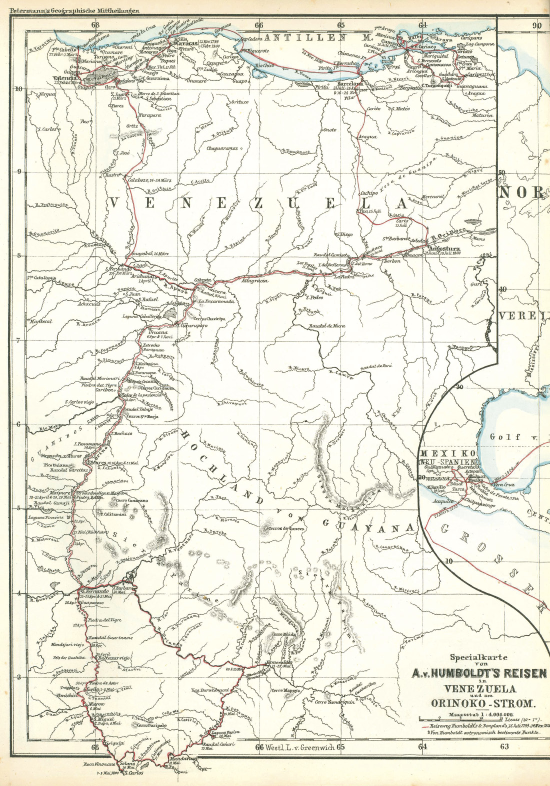
Fig. 4: Specialkarte von A. von Humboldt’s Reisen in Venezuela und am Orinoko-Strom (Petermann 1869, plate 16, between p. 320 and 321)
Reading about the stories of travelers, explorers, missionaries and surveyors, Humboldt was curious about truths and myths surrounding the almost inaccessible lowlands in the northern part of South America that were described in detail by others: the female warriors of the Amazon, the large inland lake Parima and El Dorado, the legendary land of gold. He was particularly intrigued by the stories about the sources of the Rio Negro and the Orinoco, their tributaries and the possible connections between the two river basins. The Casiquiare Canal as a key passage drew his attention. He was baffled not only by the many contradictory accounts on its existence, but also by the controversial or downright incorrect cartography and severely critiqued mapmakers who simply copied mistakes and fiction from previous maps (Humboldt 1821, 435). In a footnote in volume 5 of his Personal Narrative, Humboldt writes
[o]ur maps of America are overloaded with names, for which rivers have been created … This desire of compiling, of filling up vacancies, and of employing without investigation heterogeneous materials, has given our maps of countries the least visited an appearance of exactness, the falsity of which is discovered, when we arrive on the spot (Humboldt 1821, 775–776).
Humboldt consulted as many sources as possible to gain an idea about the mysterious canal between the Orinoco and the Rio Negro and come up with his own speculations about the topic. Though there are no records about his specific readings before his departure, it can be inferred that he was familiar with the existing geographical and cartographic sources on the Amazon basin. However, these references are only registered “after the fact” when Humboldt returned to Europe in 1804 and started to analyze his data. In his Personal Narrative, he frequently mentioned specific maps that he was possibly able to see before his departure (table 1). Other maps were probably consulted during the travel or after his return to Europe.
Besides Olmedilla’s Mapa Geográfico de America Meridional from 1775, another reference map was in Humboldt’s personal collection, according to the inventory of his library (Stevens 1863, 160): D’Anville’s Amérique Méridionale published in 1748.8 The map on three sheets covered South America from the Bay of Panama to Cape Horn. The immense area of the backlands in the Northern part appeared as an empty space over which the “veins” of the Amazon and Orinoco and their tributaries were drawn (figure 5). The hydrographic network becomes very dense closer to the Andes and even small rivers are named. Several details must have called Humboldt’s attention: the location of the legendary lake of Parima at around 4°North and 45°W (from the Ferro Meridian, Canary Islands), an immense mountain chain between the Orinoco and the Amazon in the East and the existence of at least five connections between the two watersheds, among them the “Cassiquiari”9.
|
Author |
Year |
Short title |
Comment |
|
Jodocus Hondius |
1599 |
Nieuwe caerte van het wonderbaer ende goudrijcke landt Guiana… |
Dutch map based on Sir Walter Raleigh’s travel to the Americas between 1594 and 1596. |
|
Nicolas Sanson |
1656 |
Terra Firma & Nova Granada |
French map mainly showing the lands north from the Equator. |
|
Nicolas Sanson |
1680 |
Le cours de la rivière des Amazones … |
French map based on the account Nuevo descubrimiento del gran rio de las Amazonas by the Jesuit priest Cristóbal de Acuña (1641). |
|
Father Samuel Fritz |
1690 |
Tabula geographica del Rio Maranon o Amazonas |
Manuscript map by Czech Jesuit missionary Fritz. Humboldt was able to see it in D’Anville’s Collection at the Archives of Foreign Affairs in Paris (Humboldt 1821, 837). |
|
Charles Marie de la Condamine |
1745 |
Carte du cours du Maragnon ou de la grande rivière des Amazones dans sa partie navigable … |
Map published in La Condamine’s travel account Relation abrégée d’un voyage fait dans l’intérieur de l’Amérique méridionale (1745). |
|
Jean Baptiste D’Anville |
1748 1760 |
Amérique Méridionale … |
Two different editions of a French map of all South America on three sheets. |
|
Juan de la Cruz Cano y Olmedilla |
1775 |
Mapa Geográfico de America Meridional … |
Spanish map of South America on eight sheets. Humboldt owned a copy of the original edition (Humboldt 1821, 495). |
Tab. 1: Selection of maps that Humboldt may have consulted before his America voyage
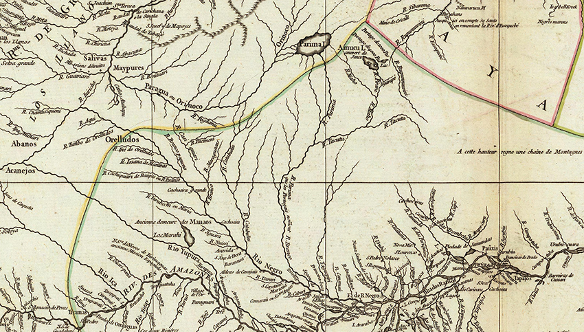
Fig. 5: Detail from D’Anville’s Amérique Méridionale (1748): The author includes Lake Parima, a mountain chain between the two watersheds in the East and several inexistent connections between the Orinoco and the Rio Negro. (David Rumsey Collection)
During his travels through South America, Humboldt dedicated much time to astronomical observations and physical measurements and calculations, which he annotated in detail. In addition to these numbers, his diaries include about 450 graphical features, from triangles, angles, circles and arcs to sketch maps, landscape profiles and drawings of species of the South American fauna and flora, including the piranha and Gymnotus electricus, the electric eel. Many of these drawings were made “on the move,” i.e., Humboldt scribbled them at the margins or close to the inner hinge of the page. Others were added as loose paper sheets or slips (Engelmann 1970, 6). A peculiarity of his diaries is the inclusion of material from others who were allowed to include information in the volumes, turning the writing into a “collaborative, communicative practice of science,” since “Humboldt stayed in a permanent exchange with colleagues of his field and friends, who not only sent him their annotations and drawings by mail, but even were allowed to add entries to his diaries, as in the case of Carlos Montúfar” (Maier 2018, 194). The young Ecuadorian aristocrat Montúfar accompanied the travel party in Ecuador and received Humboldt’s recommendation to pursue a military career in Spain in 1805. In Humboldt’s diaries, there are at least three loose sheets squeezed in between the book pages.10 These are not maps of real places, but cartographic practice training sheets. Two of them are drawn by Montúfar who rehearsed standardized forms of features such as the black rectangles of buildings along a road, river meanders, hachures to illustrate the mountain slopes and the symbolic pattern of swamp lands. One of the drawing is dated May 1802, but Humboldt added a comment more than fifty years later in September 1855 almost at the end of his life, probably browsing through the pages. He wrote “Sad memories cling to the simple lines (drawing attempts) that fill these pages. These lines are from the hand of the young Carlos Montúfar, son of the Marquis of Selvalegre, who accompanied us to Europe and whom the Spaniards shot to death. I taught him to draw maps in Quito.”11
The fact that Humboldt was “on the move” meant quick annotations and sketches, sometimes of phenomena that were visible for only a short time or, in the case of animals, were moving fast. For this reason, the drawings in Humboldt’s diaries are rarely sophisticated and crafted line tracings or ink drawings, because “the speed and the temporal rhythm of the journey influenced the aesthetic elaboration of the notes” (Maier 2018, 196). Humboldt had to develop his own fast-drawing and writing techniques in the field.
The following example from his diaries illustrate Humboldt’s “sketchy” cartography. It is a rough drawing of the Orinoco between Nueva Guayana (Humboldt’s Angostura) and Cabruta further west that Humboldt copied from the Mapa coro-gráfico de la Nueva Andalucia by Luis de Surville (1778).12 Surville, an official at the Secretaría de Estado y del Despacho Universal de Indias, modified, updated and merged two manuscript maps by the Jesuit priest Antonio Caulin who accompanied the Spanish boundaries expedition to the Orinoco in the 1750s and was one of Humboldt’s preferred references for his travels.13 The sketch does not excel in details and quality, but may have helped Humboldt visualize his itinerary up the river. Below the drawing, he adds the following observation:
Caulin mentions many more rivers than I experienced upriver from Cabruta. But I have little confidence in their existence, because I see how often 1 river becomes 3–4 due to peoples’ different idioms (Ette and Maier 2018, 356).
An exception to his rushed drawing is a more sophisticated sketch map from May 1800 (figure 6).14 The drawing was not scribbled down hastily, but carefully traced with different grey tones of ink. The back of the page shows blotches of the wet ink that infiltrated through the paper. Humboldt must have found it important to make this overview map and add it to his diary, though it cannot be confirmed that the map was drawn during his journey since it is a loose leaf between two diary pages. The drawing is entitled Inegalités du Globe au Nord de l’Amazonie. Premiere esquisse. The map shows the extreme northern part of South America. Mountain ranges like the Sierra Parima, the Sierra Nevada de Santa Marta and the branches of the Andes closer to the Pacific coast (Mer du Sud) until Quito are colored in a darker grey with hachure lines to indicate the elevations. In contrast to the mountains, the valleys of the Orinoco and the Amazon (Marañon) remain uncolored and with few details. The Casiquiare Canal and the existing portage between the watersheds of the two great South American rivers are represented in detail. The passageway between the Tuamini River and the Canno Pimichin shows two lines that almost touch each other. The polygon of Humboldt’s area of interest is imprinted with only one short comment: Bois sans Indiens—forest without Indians.
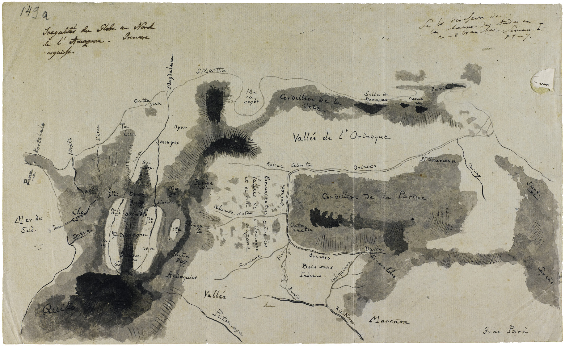
Fig. 6a: Ink drawing from Humboldt’s travel diaries; back of page with moist ink stains (Diary VII bb/c, unnumbered page (574), Staatsbibliothek zu Berlin)
Fig. 6b: Ink drawing from Humboldt’s travel diaries; back of page with moist ink stains (Diary VII bb/c, unnumbered page (574), Staatsbibliothek zu Berlin)
In the upper right corner, the German naturalist added a bibliographical reference, probably not for himself, but for other readers: Sur la division de la chaine des Andes en 2–3 branches. Seman. I, p. 4–7. This comment refers to a scientific treatise on the different branches of the Andean mountain chain, published in the first edition of the journal Semanario del Nuevo Reino de Granada in January 1808 by Humboldt’s Colombian friend Francisco José de Caldas in Bogotá. The reference was added to the map after the journey.15
In April 1800, Humboldt finally reached the upper region of the Orinoco River. Spanish missionaries in San Fernando de Atabapo gave Humboldt the approximate directions to find the passage from the Orinoco to the Rio Negro watershed. He simply had to follow the Atabapo, then the Temi and finally the Tuamini River. On the last stream, the strong current would force the traveler out of the water and enter an inundated forest that led to the place of two monks at Javita (Humboldt 1821, 195). From there it would take four days “across an isthmus six thousand toises broad, to the banks of a stream (the Canno Pichimin), which flows into the Rio Negro system” (Humboldt 1821, 197). The travel party had to carry the boats and all equipment overland.
Humboldt wrote, “[o]n the 5th of May we set off, to follow on foot our canoes, which had at length arrived, by the portage at the Canno Pimichin (rivulet). We had to ford a great number of streams; and these passages require some caution on account of the vipers with which the marshes abound” (Humboldt 1821, 279). Once again, Humboldt stressed the importance of having a hand-drawn map of the route that helped him stay on his track “in this labyrinth of rivers.” The Orinoco runs from east to west near its source and from south to north from the junction of the Atabapo with the Guaviare and the mouth of the Apure so that “those who disdain to fix their eyes on maps filled with names difficult for the memory to retain” will definitely lose their directions (Humboldt 1821, 196).
To make sure that he was able to locate himself on the map, Humboldt carried out the measurements of uncharted or incorrectly mapped places by means of a chronometer and the reading of the meridional heights of stars. Not without hubris, he claimed that:
the map I have constructed has consequently solved the doubts that remained of the respective distances of the Christian establishments. When no other road exists but that of tortuous and intermingled rivers, when little villages are hidden amid thick forests, and when, in a country entirely flat, no mountain, no eminent object is visible from two points at once, it is only in the sky that we can read where we are upon the Earth. In the wildest countries of the torrid zone we feel more than any where the want of astronomical observations. They are not only useful means of finishing and improving maps, but are indispensable for tracing the first sketch of the ground (Humboldt 1821, 199).
This way, Humboldt’s frustration on days with a cloudy sky becomes understandable. He was not able to determine the accurate location of San Carlos del Rio Negro at the borderlands between Spanish territories and Brazil. Apparently, Humboldt had his travel route on paper and in his mind, and in various different versions. He did not want to follow the path of other travelers, but think about new connections or short cuts, that would turn traveling faster and trade easier.
In the moments when Humboldt and Bonpland had decided to rest for a longer period or were impeded to continue their travels, they used their time to look at their annotations. During their stay in Angostura between June 13 and July 10, 1800 and due to his fragile health conditions, Bonpland began the drawing of his own route map (figure 7). In comparison to Humboldt’s scribbles, Bonpland’s drawing looks tidier and more organized. Mountain ranges and river valleys are clearly separated, and place names are indicated in crisp handwriting. The French naturalist added a frame of latitude (from zero to 11°N) and longitude (based on the Meridian of Paris) and indicated the borderline between the two Iberian crowns as conceived by Spain. On the reverse he wrote “Note. Sept. 1800. Je fis cette carte pendant une maladie à l’Angostura”—“I made this map during an illness in Angostura.”16
During this involuntary break, Humboldt was not idle either and worked on his own drawing, based on astronomical observations in the field and completed in Angostura in June 1800, “while Bonpland was down with the lethal typhoid fever”17. The text is on the back of a rectangle-shaped part of his Orinoco map can be found in the Radowitz Collection at the Jagellonian Library in Cracow.18 The meticulous artistic rendering of the relief is a prominent feature on the map, giving the false impression of a mountainous area. In addition to this, Humboldt still confirmed the existence of the Parima Lake further to the east and south from a Dutch settlement, the territory of the “confederate Caribes” and the “stockade of liberated negroes”.
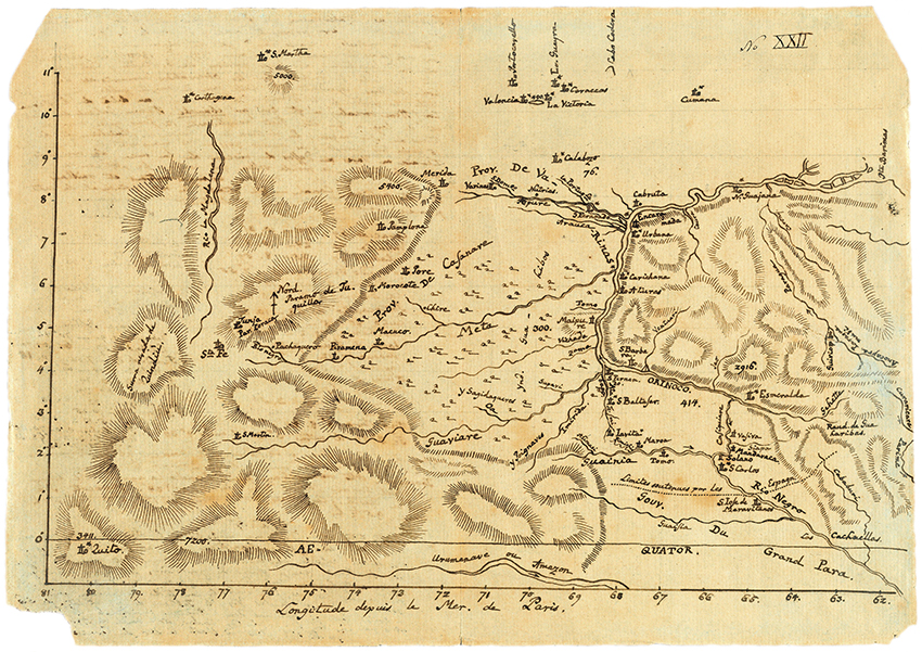
Fig. 7: Bonpland’s map of the Orinoco (1800) (John Carter Brown Library, Map Collection) https://tinyurl.com/vdhyt7s
In the lower left corner of the map that is dominated by the presence of hachured mountain tops, Humboldt depicted the portage between the Tuamini and the Canno Pimichin with an estimated distance of 6,000 toises or approximately 36,000 feet (figure 8). The latter appears, different from other rivers, as a heavily meandering line. Humboldt still thought about other places, in which the two watersheds could be connected. He added a note to the map, mentioning that there is another land bridge further west between the Inirida and the Guiainia (upper part of Rio Negro): “The Indians of Iavita and Maroa assured me that the sources of the Inirida and the Guainia are close to each other at merely 4.5 days northwest from Pimichin.”
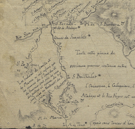
Fig. 8: Detail from Humboldt’s Orinoco map. Theil einer Karte vom Orinoco, Cracow, Biblioteka Jagiellonska, Radowitz Collection 6262
Another map sketch attributed to Humboldt is a 40×30cm pen-and-ink drawing on parchment with the title “Rio Negro, Rio Branco, Part of the Lower Iapura” (figure 9).19 The map is accompanied by another, smaller scrap, sized 15×19cm. The irregular shape of the map is owing to the fact that Humboldt seemed to have used scissors enthusiastically, maybe with the intention to “cut and paste” these pieces to other maps. In the upper right corner, he wrote “Copiez une carte de l’Orenoque”—“Copy a map of the Orinoco River.” A large oval-shaped piece is missing, and a short description to the right from the cut-out part may hint at its contents: sources of the Orinoco (question mark added), latitude 3°40', longitude 66°10'.
The map includes several coordinates, e.g., Javita (“2°48 & 7022”) and “Marapi 1°46 67.40” and a bold N to indicate the North. The main area depicted in the drawing is in Brazilian territory that Humboldt was not able to visit so that the information was most probably copied from other maps. In the lower part, he does not complete the tracing of the course of the Iapura River to its encounter with the Amazon. Humboldt leaves this for a later moment and writes a note on the paper: “Prenez le embouchure du Iapura de ma carte portugaise”—“Copy the mouth of the Iapura River from my Portuguese map.”20 Several river courses have been crossed out and almost look like railway lines. Humboldt decided to discard these features. The smaller sketch map speculates about another connection between the watersheds of the two large rivers (figure 10). The upper Rio Negro, also called Guainia, and the Inirida, which is part of the Orinoco system, appear as pointed lines that almost touch each other.
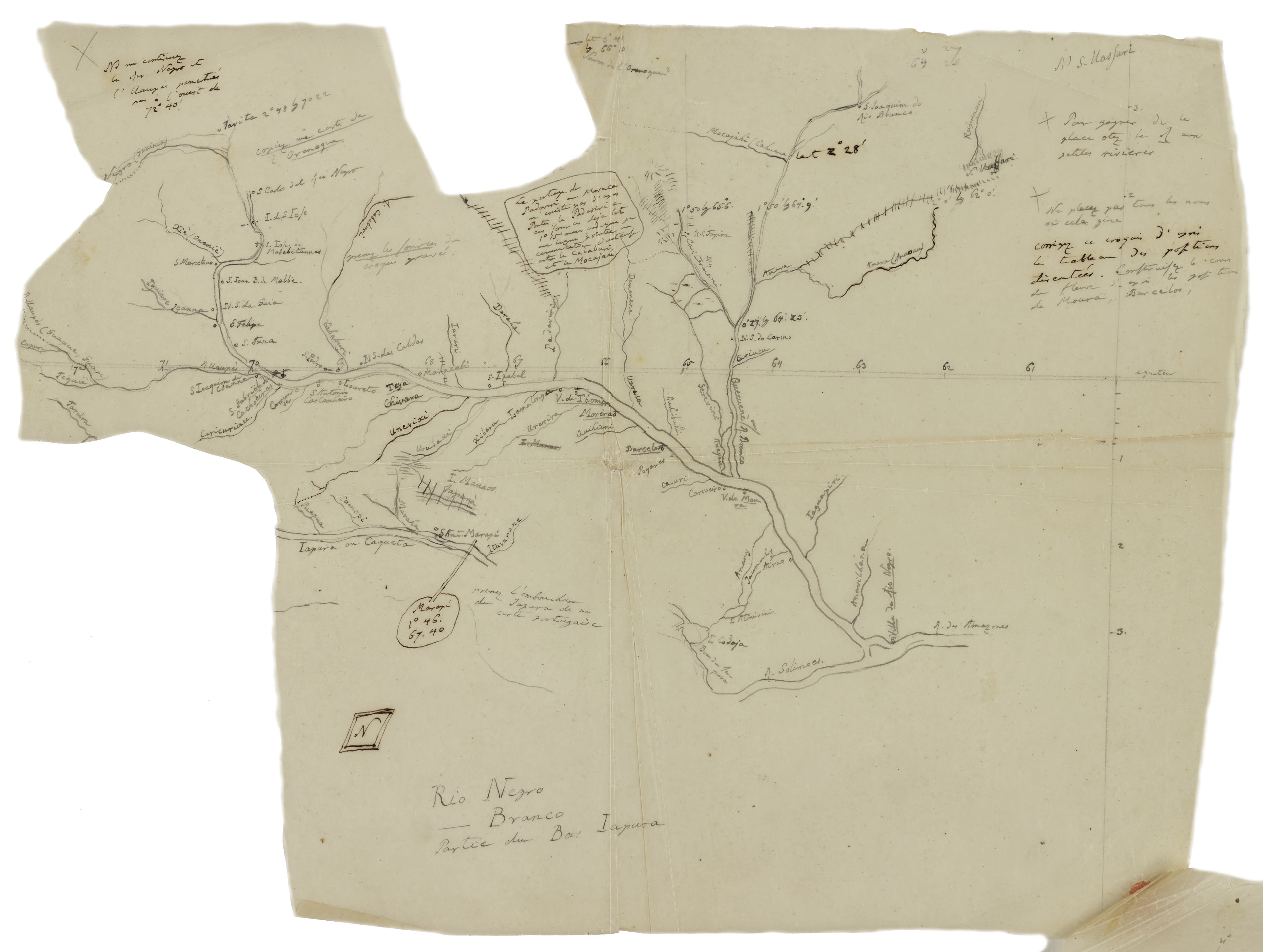
Fig. 9: Manuscript map of the Rio Negro attributed to Humboldt (ca. 1800). James Ford Bell Library, University of Minnesota
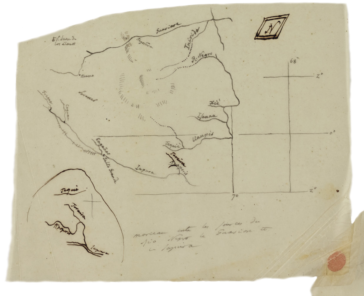
Fig. 10: Manuscript map of the Rio Negro attributed to Humboldt (ca. 1800): Cut-out sketch. James Ford Bell Library, University of Minnesota
One can only speculate about the number of map sketches that Humboldt drew during his journey. It is probable that many drawings were discarded as insufficient or incorrect or lost due to inclement weather conditions or accidents of human and physical nature. Several pages of his diaries testify to the challenge of maintaining a field diary: large ink stains and water damage from rain or river water mingle with the written text (Ette and Maier 2018, 660–672).
After his return to Europe, Humboldt worked on the analysis of his collected data and reread his materials to compile maps from his journey. His main cartographic findings based on his observations and map sketches appear in his Atlas Géographique et Physique du Noveau Continent (Humboldt 1814–1834). Plate XIII shows a comparison of river deltas and their bifurcations in Europe and South America that, according to the subtitle, served him as “enlightenment to the hydrography of the Orinoco” (pour servir d’éclaircissment aux discussions d’Hygrographie comparée). On the map sheet, Humboldt presents curiosities such as the Else and Haase rivers in Germany that flow through the same valley without mingling their waters or the complex system of river branches in French karst landscapes. South American examples are the bifurcation of the Cababuri River in Brazil (“spill of a lower tributary into a higher tributary”) and the Yapura River, also in Brazil, an example of the opposite: a higher tributary merging with a lower. Humboldt points out the paradoxical flow directions with arrows. Plate XIV, Histoire de la Geographie de l’Orenoque, specifically addresses the cartographic history of the Orinoco based on the maps and accounts by seventeenth- and eighteenth-century naturalists, cartographers, missionaries and travelers (figure 11). The map is a summary of Humboldt’s critique of the previous attempts to map the course of the river.
One of the most sophisticated drawings in Humboldt’s atlas is plate XVI, Carte Itineraire du Cours de L’Orenoque, du L’Atabapo, du Casiquiare, et du Rio Negro, showing the bifurcation of the Orinoco and its communication with the Amazon river (offrant la bifurcation de l’Orenoque et sa communication avec la riviere de l’Amazone). The map is dominated by an almost overpowering background pattern standing for “deserted forests” and river plains and the “wooly worms” of mountain ranges further to the north. Humboldt added comments on the physical landscapes, hydrography, geology and the native population. Missions (existing and destroyed) and indigenous settlements are identified. Asterisks following place names indicate the locations where Humboldt was able to make astronomical observations. Two smaller inset maps show detailed features of the Vasiva mission and lagoon off the Casiquiare and the Maypures cataracts.
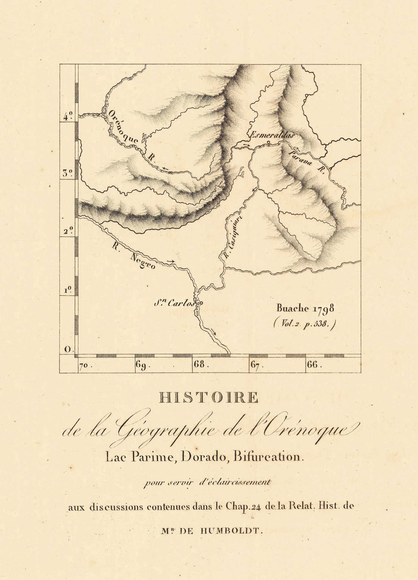
Fig. 11: Detail from Histoire de la Géographie de l’Orénoque (Humboldt 1814–1834) (David Rumsey Collection)
The map is a visual travel chronicle or even a story map that it is not static, but captures movements: “the goal of the text is to map not only the territory traversed by a river, but also the voyage of a traveler along” (Pérez-Mejia 2004, 64). A protuberance of land in the western part of the map depicts the upper course of the Rio Negro and the portage at Pimichin (figure 12). Humboldt adds the following text: “portage of 6,000 toises [one toise approximately 2 meters] through which we had to pass our pirogue from the 1st to the 4th of May, 1800.”
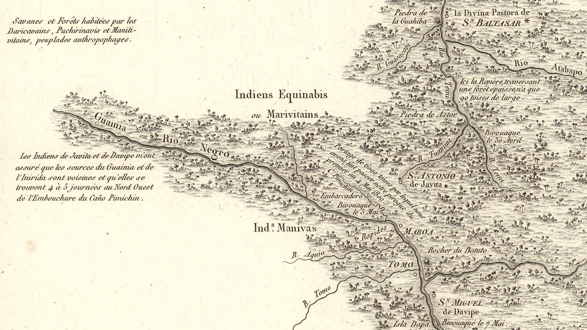
Fig. 12: Detail from Carte Itineraire du Cours de L’Orenoque, du L’Atabapo, du Casiquiare, et du Rio Negro (Humboldt 1814–1834) (David Rumsey Collection)
Based on his direct observations and measurements, Humboldt compares the two routes between the Orinoco and the Rio Negro and draws the conclusion that the Casiquiare seemed to be the “most natural way” on the map (Humboldt 1821, 197). However, first-hand experience convinced him that this was not the best solution due to the current of the stream and the numerous meanders and rapids. According to his calculations, the journey between San Carlos and Angostura would take 28 days via Pimichin and 37 days passing through the Casiquiare (Humboldt 1821, 260–261). Humboldt writes that he proposed the construction of a canal at Pimichin to the ministry of King Charles the Fourth (p. 259) so that
[w]e shall soon see the great advantage that would result from a running canal across the marshy ground between the Tuamini and the Pimichin. If this project be some day carried into execution, there would be no other obstacle to vanquish in going from the fort of San Carlos to Angostura, the capital of Guyana, than that of ascending the Rio Negro as far as the mission of Maroa; the rest of the navigation would be performed by means of the currents of the Temi, the Atabapo, and the Oroonoko (Humboldt 1821, 198–199).
Plate XXII of Humboldt’s Atlas Physique is the cartographic result of his travel through the northern part of South America. The Carte Génerale de Colombia, drawn by the French cartographer Adrien-Hubert Brué, is an overview map of the western part of the region, including the complete Orinoco basin, but cutting of the lower course of the Amazon River. Astronomic positions measured by Humboldt himself are marked with an asterisk and reference is made to his Recueil d’Observations Astronomiques (Humboldt and Oltmanns 1808). The courses of the Orinoco and Amazon are highlighted in light blue. The portage between Javita and Maroa (P. de Pimichin) and the Casiquiare canal are clearly located in the map. The upper courses of the Rio Inirida and Rio Negro close to their sources are drawn as dashed lines that almost converge but end up petering out in the hachures of a mountain range that Humboldt labeled Sierra Tunuhy (figure 13). In his Personal Narrative, Humboldt writes the following about a possible alternative portage:
The sources of the Inirida (Iniricha), I was told by the Indians, are but two or three leagues distant from those of the Guainia [one of the headstreams of the Rio Negro], where a portage might be established. Father Caulin learned at Cabruta, from an Indian chief, named Tapo, that the Inirida approaches very near the Patavita (Paddavida, on the map of La Cruz), which is a tributary stream of the Rio Negro. The natives of the banks of the Upper Guainia know nothing of this name, or of that of a lake (Laguna del Rio Negro), which is found on the ancient Portugueze maps (Humboldt 1821, 332–333).
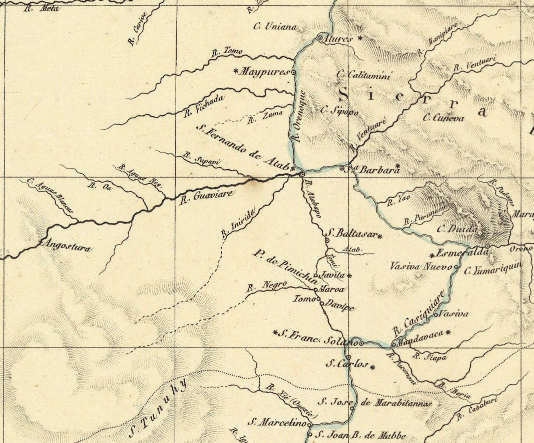
Fig. 13: Detail from Carte Génerale de Colombia (Humboldt 1814–1834) (David Rumsey Collection)
In another passage, Humboldt relates his encounter with the Cheruvichahena Indians, whom he asked about the sources of the Rio Negro:
I tried to gather from them some ideas of the upper course and the sources of the Rio Negro; but the interpreter, whom I employed, could not make them comprehend the sense of my questions. They only repeated to satiety, that the sources of the Rio Negro and the Inirida were as near to each other, as ‘two fingers of the hand’ (Humboldt 1821, 405–406).
Due to his travel route, Humboldt did not have time neither physical strength to investigate this passageway between the two river basins further. He did not find another confirmed portage between the Rio Negro and the Orinoco, but his map indicates two overland trails between a tributary of the Rio Branco (part of the Amazon basin) and a tributary of the Essequibo River that crosses British Guiana (today’s Guyana) from South to North, though not connected to the Orinoco.21
The aim of this essay was to reflect on Humboldt’s mapping impulse and how he put it into practice for and on his journey to the Americas. His cartography on the move can serve not only as a contribution to a broader debate on movements, measurements and maps in the history of science in general and the history of cartography in particular, but also as example of the dynamics and complexities of knowledge networks, thinking about Humboldt as a collector and “connector” of maps who literally united cartographic “circuits”.
Maps played a central role in Humboldt’s quest for knowledge. He used accounts and cartographic material by other authors as a starting point to correct errors, disprove myths and compile new maps, though his cartographic projects always remained as works in progress. Humboldt frequently added notes based on new literature, the discovery of maps that he did not own or know about and conversations and correspondence with other scholars. The recent online publication of his travel diaries provides further insights into Humboldt as a mapper, though details about his exact cartographic practices will probably never be found. In fact, the pages of his diaries per se can be read as maps, a collage of impressions and notes that are not written in a sequential order, but must be understood as a relational space of performance and thought.
Another aspect is how Humboldt understood the functions of maps. Humboldt wanted to locate places and their relative positions because this network of certainties would make maps more trustworthy. Humboldt’s cartography aimed to connect rather than separate. This may be the reason why he was particularly interested in rivers as links:
Rivers have sources, connect sites and may vary in their course and therefore in their relevance, a fact, which could also cause alterations in the importance of sites connected by rivers. That is why Humboldt was interested in channels—artificial or natural—in their function of connecting distant regions—and if they did not exist, he made proposals to build them (Leitner 2017, 52, translation from Spanish).
Humboldt’s geographical and cartographic imagination includes regions that he was unable to visit personally. However, based on substantial measurements and scientific observations, both his own and by others, he could map a place that he had never seen (Harvey 2000, 174). Had Humboldt been a mere cartographer instead of a restless multitasking polymath, the mapping of the northern part of South America would have been far more significant. The German naturalist admitted the limitations of his own cartographic skills, but at the same time felt the urge or even an “itch” to map. In an undated diary entry of his journey, Humboldt writes about his map of the Magdalena River:
My map was made in a hurry, while I occupied myself with comparative botany, astronomy, during a season when the rains impeded multiple astronomical observations. I know that the details are correct, the smaller slopes are indicated, it is the first drawn map of this river, despite all those engineers who have traveled on it for 300 years. I have the disgrace to be a foreigner, I will be this anyway even if I were Spanish, but I am from the same province as my judge. However accurate I create my work, it will always be judged badly, because it is made by a Prussian.22
Ultimately, Humboldt seemed to have fulfilled his personal quest and desire of a curious human being and meticulous scientist. For him, measurements were not done at the office desk, but required that the naturalist had to develop a mobility to help him locate places, compare differences, collect data and find clues to explain the physical history of the world. In this sense, maps, either as spontaneous scribbles or as sophisticated pages of an atlas, were his visual representations of measures and movements. This essay only scratched the surface of Humboldtian cartography. Many aspects of Humboldt’s “cartographic Cosmos” are still awaiting further studies.
Allen, David Y. (2014): Alexander von Humboldt and the mapping of Mexico. e-Perimetron 9(2), 78–96.
Alpers, Svetlana (1983): The art of describing: Dutch art in the 17th century. Chicago: University of Chicago Press.
Baron, Frank.; Doherr, Detlev (2006): Exploring the Americas in a Humboldt Digital Library. Geographical Review 96(3), 439–452.
Beck, Hanno (1959–1961): Alexander von Humboldt. Wiesbaden: Franz Steiner Verlag. (Two volumes: I: Von der Bildungsreise zur Forschungsreise, 1769–1804; II: Vom Reisewerk zum “Kosmos”, 1804–1859.)
Bredekamp, Horst (2015): Die Amerikanischen Reisetagebücher: ein erster Zugang. HiN – Alexander Von Humboldt Im Netz. Internationale Zeitschrift für Humboldt-Studien, 16(31), 24–40. https://doi.org/10.18443/220, [access Sept 12, 2020].
Bruhns, Karl (ed.) (1872): Alexander von Humboldt. Eine wissenschaftliche Biographie. Leipzig: F. A. Brockhaus (3 volumes).
Buchholz, Amrei (2020): Zwischen Karten. Alexander von Humboldts “Atlas géographique et physique des régions équinoxiales du Nouveau Continent”. Berlin: de Gruyter.
Cannon, Susan (1978): Science in culture. The Early Victorian Period. New York: Science History Publications.
Cervantes Saavedra, Miguel de (1833): The history and adventures of the renowned Don Quixote. From the Spanish by T. Smollett, M. D. to which is prefixed a memoir of the author by Thomas Roscoe. Volume II. London: Effingham Wilson.
Clark, Rex (2001): If Humboldt had a Laptop. Moving Knowledge Networks from Print to Digital Media. HiN – Alexander Von Humboldt Im Netz. Internationale Zeitschrift für Humboldt-Studien, 2(03). https://doi.org/10.18443/16, [access Sept 12, 2020].
Daum, Andreas (2019): Alexander von Humboldt. Munich: C. H. Beck.
De la Condamine, Charles (1745): Relation abrégée d’un voyage fait dans l’intérieur de l’Amérique Méridionale: Depuis la côte de la Mer du Sud, jusqu’aux côtes du Brésil & de la Guyane. Paris: Chez la Veuve Pissot.
De Terra, Helmut (1955): The life and times of Alexander von Humboldt, 1769–1859. New York: Knopf.
Dettelbach, Michael (1996): Humboldtian science. In: Jardine, Neil/Secord, James/Spary, Emma (eds.): Cultures of natural history. Cambridge: Cambridge University Press, pp. 287–304.
Doherr, Detlev (2005): The Humboldt Digital Library: Exploring Innovative Structures. HiN – Alexander Von Humboldt Im Netz. Internationale Zeitschrift für Humboldt-Studien, 6(10), 34–39. https://doi.org/10.18443/58, [access Sept 12, 2020].
Edition Humboldt Digital (2019): Available at https://edition-humboldt.de, [access Sept 12, 2020].
Engelmann, Gerhard (1970): Alexander von Humboldts kartographische Leistung. Wissenschaftliche Veröffentlichungen des Geographischen Instituts der Deutschen Akademie der Wissenschaften 27/28: 5–21.
Ette, Ottmar (2003): Literature on the move. Amsterdam: Rodopi.
Ette, Ottmar (2015): Icono-grafía, cali-grafía, auto-grafía. Sobre el arte de la visualización en los diarios del viaje americano de Alexander von Humboldt. HiN – Alexander Von Humboldt Im Netz. Internationale Zeitschrift für Humboldt-Studien, 16(30), 29–53. https://doi.org/10.18443/213, [access Sept 12, 2020].
Ette, Ottmar (2018): Die Humboldtsche Wissenschaft. In: Ette, Ottmar (ed.): Alexander von Humboldt Handbuch. Leben – Werk – Wirkung. Stuttgart: Metzler, pp. 106–112.
Ette, Ottmar; Maier, Julia (2018): Alexander von Humboldt. The Complete Drawings from the American Travel Diaries. Munich/London/New York: Prestl.
Gade, Daniel (2011): Curiosity, inquiry, and the geographical imagination. New York: Peter Lang.
Godlewska, Anne (1999): From enlightenment vision to modern science? Humboldt’s visual thinking. In: Livingstone, David/Withers, Charles (eds.): Geography and enlightenment. Chicago: University of Chicago Press, pp. 236–281.
Guest, Bertrand (2017): Die beschreibende Sprache Humboldts, eine dekoloniale und energetische Linienlandschaft? In: Ette, Ottmar/Drews, Julian (eds.): Landschaften und Kartographien der Humboldt’schen Wissenschaft. Hildesheim: Olms, pp. 83–101.
Harvey, Miles (2000): The island of lost maps. A true story of cartographic crime. New York: Random House.
Humboldt, Alexander von/Oltmanns, Jabbo (1808): Recueil d’observations astronomiques, d’opérations trigonométriques et de mesures barométriques, faites pendant le cours d’un voyage aux régions équinoxiales du nouveau continent, depuis 1799 jusqu’en 1803, par Alexandre de Humboldt: rédigées et calculées, d’après les tables les plus exactes. Tübingen: J. G. Cotta.
Humboldt, Alexander von (1810–1813): Vues des cordillères et monuments des peuples indigènes de l’Amérique. Paris: F. Schoell.
Humboldt, Alexander von (1811): Atlas géographique et Physique du Royaume de la Nouvelle-Espagne, Fonde sur des Observations Astronomiques, des Mesures trigonometriques et des Nivellemens Barometriques. Paris, Chez F. Schoell.
Humboldt, Alexander von (1814): Personal narrative of travels to the equinoctial regions of the new continent, during the years 1799–1804. Volumes I and II. London: Printed for Longman, Hurst, Rees, Orme, and Brown.
Humboldt, Alexander von (1814–1825): Relation historique du voyage aux régions équinoxiales du Nouveau Continent, fait en 1799, 1800, 1801, 1802, 1803 et 1804. Paris: F. Schoell.
Humboldt, Alexander von (1814–1829): Personal narrative of travels to the equinoctial regions of the new continent, during the years 1799–1804. By Alexander de Humboldt and Aimé Bonpland; with maps, plans, &c. Written in French by Alexander de Humboldt, and translated into English by Helen Maria Williams. London: Longman, Hurst, Rees, Orme, and Brown.
Humboldt, Alexander von (1814–1834): Atlas géographique et physique des régions équinoxiales du Nouveau Continent, fondé sur des observations astronomiques, des mesures trigonométriques et des nivellemens barométriques, Voyage de Humboldt et Bonpland Première Partie. Paris: Librairie de Gide.
Humboldt, Alexander von; Bonpland, Aimé (1815–1832): Reise in die Aequinoctial-Gegenden des neuen Continents in den Jahren 1799, 1800, 1801, 1802, 1803 und 1804. Stuttgart: J. G. Cotta.
Humboldt, Alexander von (1821): Personal narrative of travels to the equinoctial regions of the new continent, during the years 1799–1804. Volume 5. London: Longman, Hurst, Rees, Orme, and Brown.
Humboldt, Alexander von (1845): Kosmos. Ein Entwurf einer physischen Weltbeschreibung. Erster Band. Stuttgart and Tübingen: J. G. Cotta’scher Verlag.
Humboldt, Alexander von (1860): Briefe von Alexander von Humboldt an Varnhagen von Ense, aus den Jahren 1827 bis 1858. Leipzig: F. A. Brockhaus.
Humboldt, Alexander von/Berghaus, Heinrich (1863): Briefwechsel Alexander von Humboldt’s mit Heinrich Berghaus: aus den Jahren 1825 bis 1858. Leipzig: Costenoble.
Jöns, Heike/Heffernan, Michael/Meusburger, Peter (2017): Mobilities of knowledge: an introduction. In: Jöns, H./Meusburger, P./Heffernan, M. (eds.): Mobilities of knowledge. Cham: Springer, pp. 1–19.
Kraft, Tobias (2014): Figuren des Wissens bei Alexander von Humboldt. Essay, Tableau und Atlas im Amerikanischen Reisewerk. Berlin: de Gruyter.
Leitner, Ulrike (2001): Unbekannte Venezuela-Karten Alexander von Humboldts. HiN – Alexander Von Humboldt Im Netz. Internationale Zeitschrift für Humboldt-Studien, 2(03). https://doi.org/10.18443/19, [access Sept 12, 2020].
Leitner, Ulrike (2017): Sobre ríos y canales – Aspectos geográficos y cartográficos en el legado de Humboldt. HiN – Alexander Von Humboldt Im Netz. Internationale Zeitschrift für Humboldt-Studien, 18(34), 30–58. https://doi.org/10.18443/251, [access Sept 12, 2020].
Leitner, Ulrike (2018): Ausgaben und Übersetzungen. In Ette, Ottmar (ed.): Alexander von Humboldt Handbuch. Leben – Werk – Wirkung. Stuttgart: Metzler, pp. 252–259.
Leitner, Ulrike (2019): “Ich habe es mir zur Pflicht gemacht, alle angestellten Beobachtungen ohne Auswahl in mein Tagebuch einzutragen”. Über die Neuausgabe der amerikanischen Reisejournale. Version 5, September 11, 2019. Available at https://edition-humboldt.de/v5/H0016432, [access Sept 12, 2020].
Leitner, Ulrike/Götz (eds.) (2019): Humboldt, Alexander von: Voyage d’Espagne aux Canaries et à Cumaná Obs. astron. de Juin à Oct. 1799 [= Tagebücher der Amerikanischen Reise I], Version 5, September 11, 2019. Available at https://edition-humboldt.de/v5/H0016412, [access Sept 12, 2020).
Maier, Julia (2018): Die Zeichnungen Alexander von Humboldts in den Amerikanischen Reisetagebüchern. In: Ette, Ottmar (ed.): Alexander von Humboldt Handbuch. Leben – Werk – Wirkung. Stuttgart: Metzler, pp. 193–199.
Massey, Doreen (2005): For space. London: SAGE.
Moheit, Ulrike (ed.) (1993): Alexander von Humboldt: Briefe aus Amerika, 1799–1804. Berlin: Akademie-Verlag.
Pérez-Mejía, Angela (2004): A geography of hard times: narratives about travel to South America, 1780–1849. Albany: SUNY Press.
Petermann, August (1869): Übersichtskarte von Alex. v. Humboldt’s Reisen 1798–1829. Mittheilungen aus Justus Perthes’ Geographischer Anstalt 15, 292–294.
Radowitz, Joseph von (1864): Verzeichniss der von dem verstorbenen preussischen General-Lieutenant J. von Radowitz hinterlassenen Autographen-Sammlung. Zweiter Theil: Gelehrte. Berlin: Hübner-Trams.
Staatsbibliothek zu Berlin (2019): Alexander von Humboldt Portal. Available at https://humboldt.staatsbibliothek-berlin.de/werk/, [Access Sept 12, 2020].
Stevens, Henry (1863): The Humboldt Library. A catalogue of the library of Alexander von Humboldt. London: Henry Stevens.
Wulf, Andrea (2015): The invention of nature: the adventures of Alexander von Humboldt, the lost hero of science. New York: Knopf.
1 For a brief history of editions and translations of Humboldt’s work see Leitner (2018). In order to preserve consistency, I use the English translation of his personal narrative from the French proofs (Humboldt 1814–1829) for the discussion of Humboldt’s travels between the Orinoco and the Amazon.
2 A study of Humboldt’s biographers would be a research project by itself. Among the “classics” and the more recent publications are Bruhns (1872), Beck (1959–1961), Wulf (2015) and Daum (2019), just to mention a few works.
3 A focus on Humboldt may induce the reader to dismiss this study as colonialist and Eurocentric. I am aware of the tensions between different discourses, especially when reading 19th-century writings through the lens of 21st-century postcolonial perspectives. Unfortunately, subaltern voices in travel accounts like Humboldt’s Personal Narrative are not easy to detect or uncover.
4 For digital projects to transfer Humboldt’s works to a computer screen, see Clark (2001), Doherr (2015) and Baron and Doherr (2006). For an initial assessment of his diaries, see Bredekamp (2015). The nine volumes with Humboldt’s annotations and observations are now accessible online to provide further insights into his scientific methods and fieldwork in Latin America. In addition to the digital copies of Humboldt’s diary pages, German scholars of the Edition Humboldt Digital project (2019) at the Berlin-Brandenburg Academy of Sciences and Humanities have started to transcribe the contents of Humboldt’s diaries. A beta version of the first volume is online now (Leitner and Götz 2019). The deciphering of Humboldt’s calligraphy and the transcription of the diary pages will make his writings accessible to the broader public.
5 Humboldt Diaries IV, page 79r. The complete diaries, 14 boxes with loose papers and 15 additional cases with books and other additional material are made available by the Staatsbibliothek zu Berlin (2019).
6 The original German text is “Sie [die empirische Betrachtung] ist der alleinige Boden, auf dem ich mich weniger unsicher zu bewegen verstehe” and is curiously omitted in the English translation by Elise Otté.
7 An in-depth study of the cartographic material mentioned in his travel diaries, Personal Narrative and correspondence can provide further insights into Humboldt’s world of maps and mapping.
8 It cannot be determined if Humboldt purchased the map before or after his journey to the Americas.
9 Like any other nineteenth-century traveler, Humboldt did not always use the same spelling for place names, especially those of indigenous origin. For this reason, there are slight differences in the toponyms.
10 Diaries VII bb/c, 1801–1802, pages 308r, 408r, and 410v, reprinted in Ette and Maier (2018, 294 and 306–307).
11 Diary VII bb/c, page 308r, reprinted in Ette and Maier (2018, 294).
12 Diary IV, page 371, reprinted in Ette and Maier (2018, 256).
13 Surville’s map was attached to Caulin’s report that was published as Historia Coro-Gráphica Natural y Evangélica de la Nueva Andalucía in 1779. Humboldt considered Surville’s map a flaw and wrote sarcastically “If father Caulin could have seen the map, which has been prefixed to his work, he would have been surprised to find fictions reproduced in it, which he has himself combated by accurate ideas acquired on the spot (Humboldt 1821, 435).
14 Diary VII bb & VIIc, 149 a r, reprinted in Ette and Maier (2018. 292–293).
15 Ulrich Päßler, personal communication by e-mail, April 2, 2019.
16 The sketch is part of the Map Collection at the John Carter Brown Library, accession number C-7412. It is one of four drawings labeled as notebook fragments attributed to Aimé Bonpland, http://josiah.brown.edu/search/c?searchtype=f&searcharg=file+Ga800+&searchscope=07&SORT=D&SUBMIT=Search. The material was donated to the library in the 1970s, when the then-curator attributed the maps to Bonpland, stating that a more certain attribution would require further research (personal communication with Bertie Mandelblatt, John Carter Brown Library, 09/15/2020).
17 The original text is “Mein erster Versuch, die am Orinoco und Casiquiare gemachten astronomischen Beobachtungen graphisch zu benuzen (?). Ich habe das Blatt gezeichnet in Santo Thome del Angostura im Junius. 1800, während Bonpland am Nervenfieber tötlich krank lag. Ich gebe Ihnen das Blatt um zu beweisen, dass meine Unleserlichkeit nicht ein Urlaster ist” (Radowitz 1864, 472).
18 Theil einer Karte vom Orinoco, Cracow, Biblioteka Jagiellonska,. Radowitz Collection 6262. A short description with a copy of a truncated version of the map can be found in Leitner (2001).
19 Catalog entry (#9960364270001701) is “Manuscript Map of the Rio Negro, South America, ca. 1800”, James Ford Bell Library, University of Minnesota.
20 In his Narrative, Humboldt mentions “manuscript Portugueze maps which I possess, and which were drawn at the hydrographic repository of Rio Janeiro” (Humboldt 1821, 313).
21 Humboldt mentions that “[s]outh of the chain of Pacaraymo and of Quimiropaca, there is a portage of three days between the Sarauri (a branch of the Rio Branco) and the Rupunuri (a branch of the Essequibo). This was the portage traversed in 1739 by the surgeon Nicholas Hortsmann, a native of Hildersheim (sic), whose journal I have had in my possession” (Humboldt 1821, 480). Not much is known about Hortsmann or his diary. Humboldt owned a copy of the travel journal “in the hand-writing of the celebrated dʼAnville” (Humboldt 1821, 593).
22 Humboldt Diaries VII a and b, pages 36 r and 36v. Translation from French.

Dieses Werk steht unter der Lizenz Creative Commons Namensnennung - Nicht-kommerziell 4.0 International.
HiN - Alexander von Humboldt im Netz wird herausgegeben von der Universität Potsdam und der Berlin-Brandenburgischen Akademie der Wissenschaften.
ISSN 1617-5239 (online)
ISSN 2568-3543 (print)